The PCT Assoc posted this on their Instagram feed yesterday:
As many of you may know, he latest Sierra snow pack data is in. It is most definitely going to be a gnarly snow year for thru-hiker heading north. Snow pack is nearly 164% of normal in many areas, which is much more than hikers have experienced in recent years, since 2011. Please be safe, know the risk, and do everything you can to be prepared in order to mitigate the risk.
Snow pack like this shifts the Pacific Crest Trail from a normal summer backpacking trip, to something closer to mountaineering.
We have lots of tips over on our blog at pcta.org/discover-the-trail/backcountry-basics/snow/
Photo taken in 2005, coming down from Muir Pass during a very high snow year, late June by: Kelly Wallis
https://www.instagram.com/pctassociation/
PCTA PSA #snowpocalypse2017
-
Hobbes

- Topix Fanatic
- Posts: 1120
- Joined: Wed Apr 27, 2011 8:09 am
- Experience: N/A
- Location: The OC
-
Hobbes
- Topix Fanatic
- Posts: 1120
- Joined: Wed Apr 27, 2011 8:09 am
- Experience: N/A
- Location: The OC
Re: PCTA PSA #snowpocalypse2017
Nice overview of what to expect this (early) summer. Nothing new really, but always interesting to read other people's opinions:
https://blog.hyperlitemountaingear.com/ ... snow-year/
https://blog.hyperlitemountaingear.com/ ... snow-year/
-
Cross Country
- Topix Fanatic
- Posts: 1328
- Joined: Thu Dec 24, 2009 11:16 am
- Experience: Level 4 Explorer
Re: PCTA PSA #snowpocalypse2017
I couldn't agree more - BE EXTRA CAREFUL. And this coming from a person who went on several BP cross country trips solo. At least I didn't bag peaks solo.
-
Hobbes
- Topix Fanatic
- Posts: 1120
- Joined: Wed Apr 27, 2011 8:09 am
- Experience: N/A
- Location: The OC
Re: PCTA PSA #snowpocalypse2017
The PCTA has a nice page with photos comparing Sierra conditions for (late June) 2011and 2012:
https://www.pcta.org/discover-the-trail ... on-photos/
Donohue pass from the S
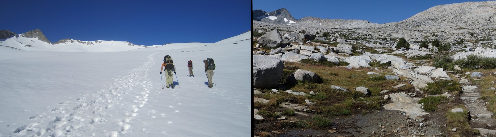
BTW, 2011 set the snow record at Mammoth with 669" inches. While 2017 may not reach that level, it's definitely on track to cross over 600", making it the second heaviest snow year since MM began keeping records in 1969:
http://www.mammothmountain.com/winter/m ... nd-weather
So, for people planning a late June trip (or perhaps even into early July), the 2011 photos provide a good idea on what to expect.
https://www.pcta.org/discover-the-trail ... on-photos/
Donohue pass from the S
BTW, 2011 set the snow record at Mammoth with 669" inches. While 2017 may not reach that level, it's definitely on track to cross over 600", making it the second heaviest snow year since MM began keeping records in 1969:
http://www.mammothmountain.com/winter/m ... nd-weather
So, for people planning a late June trip (or perhaps even into early July), the 2011 photos provide a good idea on what to expect.
-
Jimr

- Forums Moderator

- Posts: 2178
- Joined: Fri Jul 31, 2009 2:14 pm
- Experience: Level 4 Explorer
- Location: Torrance
Re: PCTA PSA #snowpocalypse2017
I was surprised to see that several have been on trail over 20 days already.
If you don't know where you're going, then any path will get you there.
-
Lumbergh21
- Topix Expert
- Posts: 632
- Joined: Mon Oct 31, 2016 10:11 pm
- Experience: Level 3 Backpacker
Re: PCTA PSA #snowpocalypse2017
Yeah, if they are planning on flipping, I don't know where they are planning on flipping to. Most likely, the trail north of the Sierra will still be buried in several feet of snow come May. Maybe they plan on taking it really slow for the first 700 miles, like 2 months. Even then they will be at Kennedy Meadows mid May.Jimr wrote:I was surprised to see that several have been on trail over 20 days already.
As for me, I might have to break down and go backpacking in Whiskeytown NRA or find some other low elevation relatively wilderness place in the early season, the Trinities and Marbles won't be doable until July IMO.
Who is online
Users browsing this forum: Bing [Bot], truchas13102 and 169 guests