Part 1:
Plan A- take off trail route from Tioga Road above Tenaya Lake to Cathedral lakes and spend 2 nights, the take trail and cross country to Sunrise Lakes spend 2 nights then hike down to Tenaya lake. This trip was due to start July 7. My plan was to arrive at TM on July 4 and spend a couple of days doing day hikes and getting acclimated.
Plan B--When it became evident that only Tehipite Tom and I would be able to make the entire trip and Tom was going to start a couple of days early and then hook up at Cathedral Lakes I did an audible and asked Tom if I could accompany him the first couple of days of his trip. It turned out just great because I had a tent cabin at the lodge reserved for the evening of the 4th and tom had no place to stay and tom would be arriving early on the 4th and could add me to his permit to enter via Elizabeth Lake/Nelson Lake TH.
Our plan: Day 1 Hike to Nelson Lake, Day 2 hike to Matthes Lake, Day 3 hike to Upper Cathedral Lake, Day 4 Layover and meet Giant Brookie at Lower Lake for day of Fishing (Tom doing whatever Tom does on Layover days), Day 5 hike to Middle Sunrise Lake, day 6 Layover, day 7 hike down to Tenaya Lake.
The Trip
After driving down from Bend arrived at TM about 4 and met up with Tom at TM lodge then drove over to TM store to Say Hi to markskor and invite him over for dinner at the lodge with us. As I recall Mark agreed to meet us at Middle sunrise on Sunday.
Next day I left my food supplies for my next trip the following week in mark’s bear box behind the Tuolumne Store. The one glitch in our plans was that there was now a charge for using the TM shuttle. 5 dollars each way between TM and Tenaya Lake per person. At $20 to rely on the shuttle we decided to park a vehicle at Tenaya Lake and one at the Th parking area in the TM campground. Seems really strange and counterproductive when the park wants reduce use of private vehicles then to institute a prohibitive charge for using the shuttle. A nominal charge makes sense but this was ridiculous!
The hike to the outlet of Elizabeth was uneventful but we followed an obvious user trail s but it turned out not to be the one that headed to the pass. Knowing the trail had to be west of us we headed up the slope to the west and after a little bushwacking found the trail. Near the top of the pass we encountered a little snow but it was still firm enough that we didn’t posthole at all. Down the canyon then following a user trail we worked our way up to Nelson, crossed the outlet stream and and quickly found suitable sites for our tents and a cooking area--all well separated. Fishing around the lake I landed just a single Brookie and wished that I had brought my raft as the shoreline is very shallow. Then I decided it was cocktail hour so I marched about a half mile to where I had spotted a snowfield when topping the rise before dropping down to the lake. We shared our backcountry daiquiris and some hors d'oeuvres before dinner.
Next am we recrossed the outlet stream and rather than retracing our steps on the user trail decided to parallel the stream until we got to the broad valley that slopes down from the ne. Embarrassingly we never detected that valley and continued on down another half mile before deciding that we should cut up and over the ridge dividing the Nelson Lake outlet stream from Echo Creek. Over the ridge it was an interesting walk up the Echo Creek Canyon and to the base of the saddle that leads to Mathes Lake. Turns out Tom is as much a sissy as I am when it comes to steep slabs but we soon negotiated the saddle and found a suitable campsite about 80 feet above the se corner of the lake. Snow was much closer to this site so we again had frozen cocktails and hors d'oeuvres before a dinner of brookies.
to be continued
TR: 2016 Old Fart Trip
-
oldranger

- Topix Addict
- Posts: 2861
- Joined: Fri Jan 19, 2007 9:18 pm
- Experience: N/A
- Location: Bend, Oregon
TR: 2016 Old Fart Trip
You do not have the required permissions to view the files attached to this post.
Mike
Who can't do everything he used to and what he can do takes a hell of a lot longer!
Who can't do everything he used to and what he can do takes a hell of a lot longer!
-
oldranger
- Topix Addict
- Posts: 2861
- Joined: Fri Jan 19, 2007 9:18 pm
- Experience: N/A
- Location: Bend, Oregon
2016 Old Fart Trip, part 2
On the morning of day 3 we were seranaded by a coyote located near the ne corner of the lake. Soon it sauntered across the tundra at the n. end of the lake then down the w. shoreline flushing a deer ahead of it before we lost it in the woods at the sw corner of the lake. Leaving the campsite and crossing the outlet stream we soon found a user trail that headed down to then up Cathedral Creek. About halfway up to Echo Lake we encountered about 100 feet of a tape measure next to the creek. I was pretty sure it was part of a research project but was it ongoing or inadvertently left after completion? I finally decided to leave it. About the time we arrived at Echo lake we met a group of people (the first we had seen since about 200 yards up the trail out of TM campground) with partially filled packs. Turns out they were studying macro invertebrate populations in waterbodies scattered throughout the Sierra and it was their tape. One purpose was to get baseline data in some waters that were scheduled to have fish removed and to compare the effects of different means of fish removal. Our discussion expanded to cover the SEKI EIS for restoration of MYLF and it was interesting that he was another person (in addition to myself and several others) that argued against using Rotenone to kill fish because some types of macro invertebrates do come back after application of rotenone (as the NPS acknowledged the EIS but decided didn’t matter). I also mentioned that I was surprised that there were still fish in the creeks after so many consecutive drought years. He said that it was surprising but very few fish bearing streams went dry last year.
After the conversation Tom took off toward upper Cathedral Lake and I hung around to fish Echo which I had passed up on my previous visit to the lake. I never saw a fish in the lake nor got a bite despite a good population of brookies in the stream both above and below the lake. So off I went in search of Tom and the lunker brookies reported by Giant Brookie just a few days earlier. Enroute to Cathedral Pass I began to understand why relatively few steams went dry the previous year. About the last 1/2 mile to the top of Cathedral Pass was a soggy meadow. The light came on! Unlike many lakes in the Sierra that, after the Glaciers passed, were left with a bedrock dam that once inflow decreases to the point where there is no outflow a meadow can drip, drip, drip slowly and continue to provide water below. Similarly a lake with a morainal dam can also provide seepage and while the immediate outlet may be dry somewhere downstream the stream may come alive again from a spring. Duh!
As I approached the pass people were visible trudging up the John Muir trail. Dropping down the trail a ways cutting off to the northwest seemed appropriate as we had decided based on Markskor’s recommendation that there were campsites available around that part of the lake. Tom yelled at me from above as I came into view along the shoreline. He had checked out the sites and led me to the alternatives. We agreed on the highest site available with space for two tents separated by a nice cooking area. Oh yeah there were lots of mosquitos down by the lake but not as many up by our site and the snow patch was really close! Despite seeing a school of brookies close to shore nothing I could do enticed them to hit anything I had to offer. I also scouted a direct route down to the lower lake where I planned on meeting Giant Brookie the next day as the trail route was pretty circuitous. While at our campsite in mid afternoon a large mixed group that reeked of “Sierra Club” passed below our site obviously looking for a campsite, which they found a couple hundred yards west of the lake that looked to me like mosquito heaven. My guess is that there were close to 20 people in total camped around the lake, including us.
Next morning Tom headed off to explore Budd Lake and I worked my way down to lower Cathedral. Even though I had seen pics of lower cathedral and viewed it from the distance before I was really impressed by the huge smooth granite outcropping that formed the eastern shore. There had been at least as many people camped at the lower lake as at the upper, including one boy scout troop. Fishing was slow, make that no bites and I worked my way to the sw shoreline keeping my eye on the north shore. After a while I noticed a person walking east along the north shore at the north east corner the person stopped for a few minutes then began fishing. So I yelled “John!” he answered something so I began working my way to the east shoreline a sure enough it was our friend Giantbrookie! Soon we retraced my route from earlier in the morning. At upper cathedral we took different routes around the lake. Eventually meeting at the spit sticking into the se corner of the lake. John managed one fish I think I was skunked. Tom had returned from his trip so we set up for our obligatory old fart pic. John soon took off and as he reported last summer made a few last casts in the lower lake but to no avail. The next morning we were back over Cathedral Pass and on the Muir Trail, past Tresidder Peak and Columbia Finger with outstanding views of the SE portion of the Cathedral Range, the Upper Merced Basin, and the Clark Range. As soon as we got close to the creek thru Long Meadow we left the trail, crossed the creek and headed up the saddle that leads to Upper Sunrise Lake. The mosquitoes at Upper Sunrise were about as nasty as they get so we moved quickly along the north shore, hit the trail for a short stretch then skirted the west shore of middle Sunrise Lake finding another nice site on top of the ridge to the west of the outlet. A nice breeze and being above and away from the water minimized impact of the mosquitoes. A little fishing in the afternoon resulted in two hits but no fish landed. Sadly there was no snow to be had near the camp so no frozen cocktails! The next day, Sunday dawned quite cloudy and we spent some time debating Tom’s plan to hike to the top of Clouds rest. Reading the clouds as best as two experienced old farts were capable we decided it was a go while I would return to Upper Sunrise to play with the brookies and bring home enough for dinner. Well I played to my hearts content and brought home the foundation of our dinner. By the way, Russ, nothing exploded or got burned on this trip! Tom made me feel like I wasn’t the only wimp in the Sierra again by reporting that he opted not to go up the final 4 foot wide trail up to the top of Clouds Rest and instead opted for a comfortable wide spot where he could watch others defy death!
When we returned to camp Mark had not arrived and would not. Was he dead somewhere on the trail? Well bears would not likely carry off his carcass before we would head down the next day so we would know by the time we reached Tenaya Lake. Cheered by that thought we started our fire, drank cool cocktails, ate barbequed brookies, and watched the sunset. Life was good despite the possible demise of Mark.
Next day the hike down to Tenaya Lake seemed interminable, expecting to encounter the partially consumed carcass of Mark, not to mention the constant down hill with unexpected climbs to further discourage us. At last we arrived at Toms car. Loaded up and drove to the TM store to see what actually happened to Mark. Well the clueless old fart accused us of being a day late! And said that he was about to send out the rangers. I don’t know how much more explicit we had to be. If it had just been me I might have conceded that I had miscommunicate but Tom was with me and we were both clear. Anyhow no time to argue. Tom had a long drive to the City and wanted to arrive before rush hour and I had to meet a friend in Mammoth to prep for our next trip.
Thththats all folks!
I'm hoping that Tom can add some photos to fill in the blanks. And he can also correct my mistakes. I'm sure that Mark will provide an "alternative reality!"
You do not have the required permissions to view the files attached to this post.
Mike
Who can't do everything he used to and what he can do takes a hell of a lot longer!
Who can't do everything he used to and what he can do takes a hell of a lot longer!
-
balzaccom

- Topix Addict
- Posts: 2968
- Joined: Wed Dec 17, 2008 9:22 pm
- Experience: N/A
Re: 2016 Old Fart Trip, part 1
Nice report. We've done most of those lakes and trails one way or the other, and never been excited about the fishing in any of them. But it is glorious country. Thanks for posting.
Check our our website: http://www.backpackthesierra.com/
Or just read a good mystery novel set in the Sierra; https://www.amazon.com/Danger-Falling-R ... 0984884963
Or just read a good mystery novel set in the Sierra; https://www.amazon.com/Danger-Falling-R ... 0984884963
-
rlown

- Topix Docent
- Posts: 8225
- Joined: Thu Oct 25, 2007 5:00 pm
- Experience: Level 4 Explorer
- Location: Wilton, CA
Re: 2016 Old Fart Trip, part 1
When Tom's dish explodes, but still tastes great, there is no argument. When OR burns a simple dessert recipe because the stove is too hot, we have an issue.oldranger wrote:By the way, Russ, nothing exploded or got burned on this trip! Tom made me feel like I wasn’t the only wimp in the Sierra again by reporting that he opted not to go up the final 4 foot wide trail up to the top of Clouds Rest and instead opted for a comfortable wide spot where he could watch others defy death!
Great TR you guys..
I'm with Tom on the comfortable wide spot. Guessing you didn't practice your yoga balance moves on Clouds Rest, OR.
-
oldranger
- Topix Addict
- Posts: 2861
- Joined: Fri Jan 19, 2007 9:18 pm
- Experience: N/A
- Location: Bend, Oregon
Re: 2016 Old Fart Trip, part 1
Hell, I went fishing!I'm with Tom on the comfortable wide spot. Guessing you didn't practice your yoga balance moves on Clouds Rest, OR.
Mike
Who can't do everything he used to and what he can do takes a hell of a lot longer!
Who can't do everything he used to and what he can do takes a hell of a lot longer!
-
rlown
- Topix Docent
- Posts: 8225
- Joined: Thu Oct 25, 2007 5:00 pm
- Experience: Level 4 Explorer
- Location: Wilton, CA
Re: 2016 Old Fart Trip, part 1
And that is the correct response!
-
Jason
- Topix Regular
- Posts: 324
- Joined: Fri Jun 19, 2009 11:13 am
- Experience: N/A
Re: TR: 2016 Old Fart Trip
Awesome report! I loved tagging along. Thanks for taking the time to post some inspiration.
-
TehipiteTom
- Founding Member
- Posts: 953
- Joined: Thu Aug 24, 2006 8:42 am
- Experience: Level 4 Explorer
Re: TR: 2016 Old Fart Trip
Excellent report (and most of it is even true, more or less!), really nice photos (I'll add a few of mine shortly). Really enjoyable trip!

ETA: on my way from Clouds Rest back to camp I conversed with a woman headed up, and she said a friend had told her (about that last, scary section) "remember: there's no shame in crawling." Which was something I had actually considered, except that then other hikers would be backed up behind me and I'd be like some damn Cruise America RV on Highway 120.
I named the place where I stopped Hesitation Point, because it's where everyone looks at the trail ahead and...hesitates. The view from Hesitation Point was quite spectacular enough for me, thank you.Tom made me feel like I wasn’t the only wimp in the Sierra again by reporting that he opted not to go up the final 4 foot wide trail up to the top of Clouds Rest and instead opted for a comfortable wide spot where he could watch others defy death!
ETA: on my way from Clouds Rest back to camp I conversed with a woman headed up, and she said a friend had told her (about that last, scary section) "remember: there's no shame in crawling." Which was something I had actually considered, except that then other hikers would be backed up behind me and I'd be like some damn Cruise America RV on Highway 120.
-
TehipiteTom
- Founding Member
- Posts: 953
- Joined: Thu Aug 24, 2006 8:42 am
- Experience: Level 4 Explorer
Re: TR: 2016 Old Fart Trip
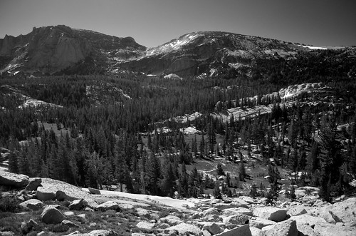
View north from the pass south of Elizabeth Lake
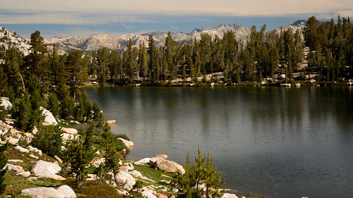
Nelson Lake
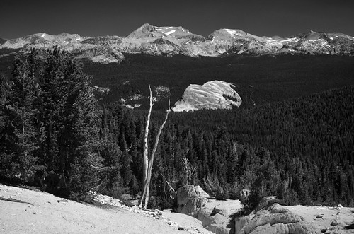
Echo Creek Valley
Matthes Lake
Matthes Lake
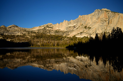
Echo Lake and Echo Peaks
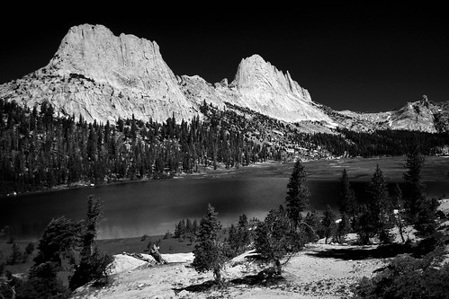
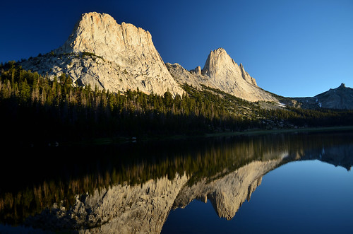
Cathedral Peak & Lake
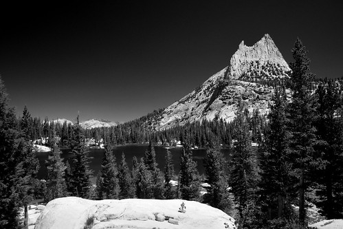
Cathedral Peak
Budd Lake
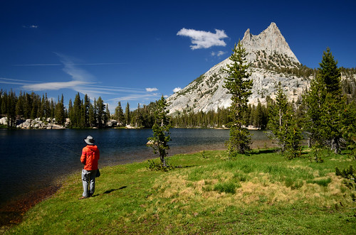
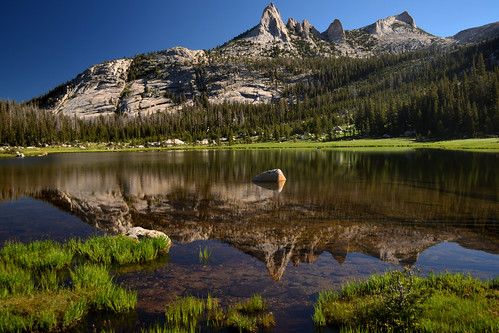
Oldranger at Upper Cathedral Lake
-
TehipiteTom
- Founding Member
- Posts: 953
- Joined: Thu Aug 24, 2006 8:42 am
- Experience: Level 4 Explorer
Re: TR: 2016 Old Fart Trip
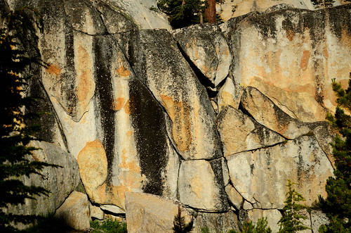
Granite at Upper Cathedral Lake
Mt. Hoffmann from near Middle Sunrise Lake
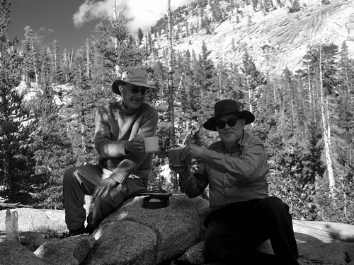
Happy Hour at Middle Sunrise Lake
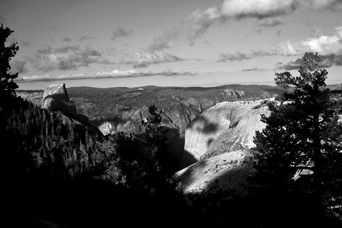
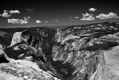
Half Dome and Yosemite Valley from near Middle Sunrise Lake
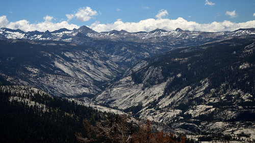
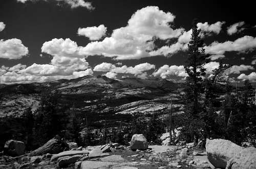
Merced River canyon from the Clouds Rest trail
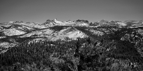
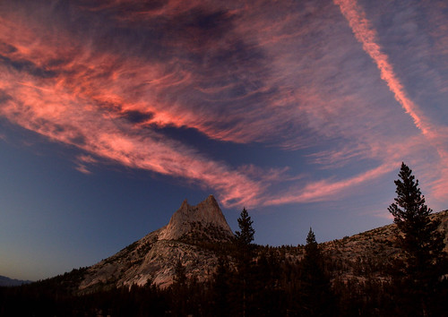
Cathedral Range from Hesitation Point
Yosemite Valley from Hesitation Point
Who is online
Users browsing this forum: Bing [Bot], Google Adsense [Bot], Thebrenner and 107 guests