Page 1 of 3
TR: XST 2016 ~ Cross Country Sierra Traverse
Posted: Fri Sep 02, 2016 1:52 pm
by Bluewater
This year the mountain gods provided a tremendous opportunity. . . a three week window during the prime summer season to explore the High Sierra. Through a series of unplanned circumstances my usual one week trip morphed into a three week epic adventure!
I stitched together portions of the Sierra High Route, South Sierra High Route, Kings Canyon High Basin Route along with some of my favorite cross country alternatives to create a cross country traverse of the High Sierra. The route started at the Twin Lakes trailhead near Bridgeport in the northern Sierra and ended at Whitney Portal via the Mountaineers Route.
In the end I climbed 25 High Sierra Passes over 257 miles in 22 days. I started preparing for the trip in January and followed Alan Dixon’s training program up to the start in July. Some of the climbs and long days were more challenging than I anticipated and the fields of wild flowers at the beginning almost derailed the whole trip. Although I planned on climbing 31 passes over 295 miles I had to skip the sections from the Lyell Fork to Mammoth and Ionian Basin due to allergies. Fortunately I was able to re-energize during a zero day and get back into the wilderness to finish the route.
For the whole story including route details, map, photos and gear list check out:
http://seatosummitultralight.blogspot.c ... -high.html
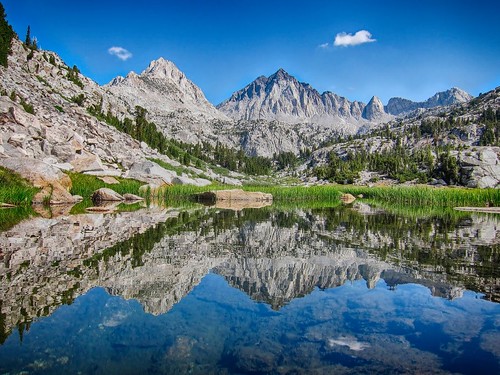
Mt. Ansel Adams from the HST Meetup Camp #3:
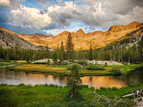
Morning reflection on Laurel Creek:
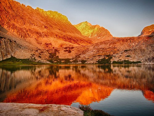
Alpenglow from Lower Mills Creek Lake:
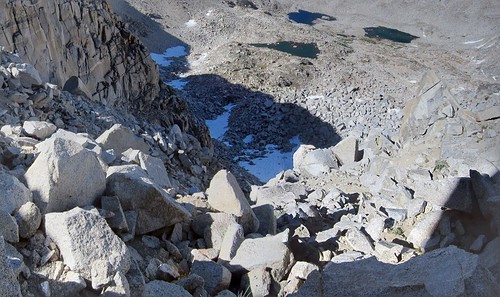
Looking back down the steep north side of Snow Tongue Pass:
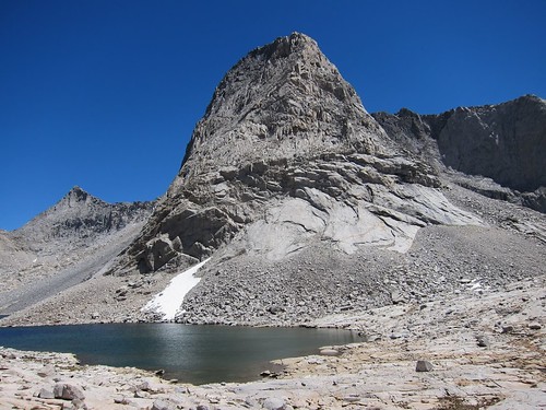
Larry Conn memorial lake:
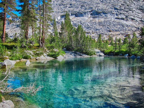
Mysterious emerald pools:
Re: XST 2016 ~ Cross Country Sierra Traverse
Posted: Fri Sep 02, 2016 2:34 pm
by maverick
That was a fun read and really enjoyed the great photo's BW. Stanton Pass wildflowers look fabulous.

Re: XST 2016 ~ Cross Country Sierra Traverse
Posted: Fri Sep 02, 2016 3:45 pm
by Bluewater
Thanks Maverick! It was good to finally meet you at the Meetup (great camp site location BTW).
Re: XST 2016 ~ Cross Country Sierra Traverse
Posted: Sat Sep 03, 2016 10:27 am
by Hobbes
Beast mode. Anything left in the Sierra to visit? What's next, the Wind River high route (another Alan Dixon production)?
https://carrotquinn.com/2016/08/29/the- ... igh-route/
Re: XST 2016 ~ Cross Country Sierra Traverse
Posted: Sat Sep 03, 2016 1:28 pm
by Bluewater
Yes! The Wind River High Route looks like fun. . . and an excuse to visit family in Montana.
Re: XST 2016 ~ Cross Country Sierra Traverse
Posted: Mon Sep 05, 2016 10:18 am
by jrad
Fantastic set of photos! Great route.
Re: XST 2016 ~ Cross Country Sierra Traverse
Posted: Mon Sep 05, 2016 8:50 pm
by SSSdave
59.jpg "Mt. Gabb from Laurel Creek" sb Recess Peak. They have somewhat similar shapes from the north. The ridge in front across the canyon is 11,661. The point sticking up right of Recess is peak 12188.
62.jpg "Mt. Izaak Walton & Red and White Peak from Laurel Lake." Beautiful lake reflection well done! That meadow zone at 11,170 feet has been near the top my list for several years as a location to base camp at as the view you captured is one of the best peak perspectives in the Sierra though you are the first person I've seen with a picture of it. Most groups going north are too intent on reaching Grinnel or Laurel Lakes where the peak views are not as impressive. That is not Mt Izaak Walton which is far out of view left and a peak two of us climbed from a camp at Bighorn Lake in 1994. That is the no name peak 12200+ northeast of Bighorn Lake that we call The White Crags that presents a beautiful view from Mott Lake. At these cross hairs:
http://mapper.acme.com/?ll=37.47162,-118.86007&z=15&t=T
70.jpg "Lower Mills Creek Lake." sb Lower Mills Creek below the lake
As you found, it is a superb location to catch late light on the towering avalanche chutes of the ridge east. And also there are some small ponds nearby to catch dusk color west.
I went through the last several days of your trip quickly just looking at images and will need to read it when I have some time. So you didn't bring enough food. Your weight was adequate per day and 23 pounds of food is quite a load. Obviously you could not fit that in canisters. I hate the anti Ursack policy in the National Parks when traveling in remote timberline areas.
Over the years I've met quite a few people in the backcountry that didn't bring much food, especially snack food. Not a few only carry the minimum freeze dried dinners and a pitiful few snack bars. We would croak on such a meager diet. I'm a small thin wiry old guy. Strenuous hiking makes me really hungry. We tend to bring more food than we ever eat, especially snack food, candy, and rich stuff we almost never eat at home. I just packed today for a 5 day 4 night trip starting this Thursday to Dusy Basin. My food weight is about 6.7#, the Garcia is fully stuffed, and I'm going to add something on the drive up like a fresh turkey sandwich from Subway I'll eat for lunch on the way to the pass and probably some sweet rolls fron Vons.
Re: XST 2016 ~ Cross Country Sierra Traverse
Posted: Tue Sep 06, 2016 9:31 am
by Ballpeen
Incredible trip! We were also captivated by those emerald pools earlier this summer. Probably my favorite swim spot of all time. I noticed the bottom of the creek was bleached white for its whole length in that basin. Similar to photos I have seen of nearby White Fork. Does anyone know the cause?
Re: XST 2016 ~ Cross Country Sierra Traverse
Posted: Tue Sep 06, 2016 10:14 am
by balzaccom
"62.jpg "Mt. Izaak Walton & Red and White Peak from Laurel Lake." Beautiful lake reflection well done! That meadow zone at 11,170 feet has been near the top my list for several years as a location to base camp at as the view you captured is one of the best peak perspectives in the Sierra though you are the first person I've seen with a picture of it. Most groups going north are too intent on reaching Grinnel or Laurel Lakes where the peak views are not as impressive."
We camped there are few years ago over 4th of July weekend, when the lakes themselves were frozen over, and the route to the lakes was a mess because of an avalanche.
Photos here:
https://goo.gl/photos/eAwCsWPWd8sSMgjT6
https://goo.gl/photos/XweY1vxJJtDNgMV69
Here's the whole album:
https://goo.gl/photos/FEgRzUZa5F5XiND8A
Great area.
Re: XST 2016 ~ Cross Country Sierra Traverse
Posted: Tue Sep 06, 2016 5:17 pm
by Bluewater
jrad wrote:Fantastic set of photos! Great route.
Thanks jrad!