Page 2 of 3
Re: Planning Southern Emigrant Trip June 15
Posted: Thu Jun 09, 2016 12:55 pm
by justm
A little ways down stream toward the trail to Rosasco , theres a large log that spans the deepest part of the fast moving water. It takes some time finding it. It will take you to an island in the middle ( the stream is wide and spread out here) From there you'll have to do a little bushwhacking to get to another smaller log. Take that one over to a shallower area and wade the rest of the way over, usually about knee deep and cold.
Re: Planning Southern Emigrant Trip June 15
Posted: Thu Jun 09, 2016 1:31 pm
by shuteye
I've mentioned it before, but on an early season trip some years ago, I was stopped at the crossing to Gem Lake by a swollen West Fork Cherry Creek. After scouting a few football fields of shoreline, I thought the best spot was a bit north of the trail crossing, 80 feet wide and shoulder deep. I thought it was a swim. I'm a carpenter and pretty good at estimating distance.
Not wanting to backtrack, I decided to see if I could go directly from where I was on West Fork to Leopold Lake by going up the steep southeastern shoulder of the Leopold lake plateau. I had a 30lb pack and my recollection is that most of it was not on rock, and not really 3rd class, though I had to pick my way. I spent the night up there, where it was all snowed over including Leopold.
Re: Planning Southern Emigrant Trip June 15
Posted: Thu Jun 09, 2016 6:28 pm
by justm
Thanks shuteye for the advice, I'm going to go through pine valley , crossing Cherry there, if possible. I can still go to Buck lakes, Deer and take the route from Deer over to Woods and head up from there, going back the way I came.
Re: Planning Southern Emigrant Trip June 15
Posted: Sat Jun 11, 2016 7:33 pm
by Love the Sierra
HI,
I am new to your group and cannot thank all of you enough for the great info!!!
We were planning a trip, leaving Monday, from Crabtree to Piute to Wire, Emigrant and back again. The stream crossing seem a bit too deep for our skill level and I would worry about my dogs crossing safely.
That said, I am considering plan b as a trip out of Maxson trailhead by Coutright reservoir. I wills tart a new thread.
Thanks again!!
Re: Planning Southern Emigrant Trip June 15
Posted: Mon Jun 13, 2016 6:35 am
by kpeter
My trip has been delayed from June 15 to June 23 for personal reasons, so hopefully that will also help with the water crossings as the water continues to come down. I don't know if the mosquitoes can be any worse than they would have been, but I will find out! Meanwhile, those of you heading into Emigrant be sure to give us trip and condition reports--they would be much appreciated.
Re: Planning Southern Emigrant Trip June 15
Posted: Wed Jun 15, 2016 7:16 am
by kpeter
I just noticed that a little upstream from Yellowhammer lake is "Leighton Camp" which I shall try to visit when I am in the area.
"Yellowhammer Camp was constructed as a base for promoting, building, and serv1cmg check dams throughout the Emigrant Basin. The check dam concept was an integral part of the watershed and fish and game habitat conservation movement in California beginning in the late 1920s."
https://www.nps.gov/nr/feature/places/13000142.htm
Elsewhere on the board I learned about Leighton and the check dams--after I found one at the outlet to Long Lake and began to discover that many of the lakes in the region are not entirely natural.
viewtopic.php?f=27&t=8396
It seems that Yellowhammer Camp was where the base of operations was centered. I wonder if the trails in and out of Yellowhammer--and this part of Emigrant in general--were much more established and better maintained in the past when this camp was active?
The other question is whether all the check dams continue to be maintained now that Leighton's operations have been abandoned? Are the many lakes in Emigrant that have been raised by check dams going to revert to their natural state over time>?
I found this article, but it is nearly a decade old:
http://www.agalert.com/story/?id=905
At the time it was written, the Forest Service was apparently under court order not to maintain the dams.
I still wonder whether these lakes will be allowed to revert. It probably won't take too long if there is no maintenance being done.
Re: Planning Southern Emigrant Trip June 15
Posted: Wed Jun 15, 2016 7:37 am
by venturefar
The courts final decision was to not maintain the dams and the Forest Service went with the no action option presented in the EIS found here.
viewtopic.php?f=9&t=13284
If I remember correctly they expect it will take 50-300 years for the dams to erode away. depending on the dam.
Re: Planning Southern Emigrant Trip June 15
Posted: Wed Jun 15, 2016 2:03 pm
by kpeter
Thank you for that! I also found this link which has a copy of the final court decision:
http://web.stanford.edu/~yesavage/Emigrant3.html
I wonder what the lakes will be like once the dams fail. In some cases they have been raised 8-10 feet. Many of the lakes must have been much smaller before the 1920s when the check dams began to be built.
But even without the dams failing, one of their main purposes was to maintain constant stream flows to support fishing streams. That has been discontinued and so the streams must be more intermittent than they were when the dam outflows were being controlled. The Google Earth image of W Fork Cherry Creek was taken at a time when it was a series of pools--I supposed when the dams were controlled that the creek flowed year round? So the reversion process has already begun.
IMGP2953.jpg
Re: Planning Southern Emigrant Trip June 15
Posted: Wed Jun 15, 2016 5:01 pm
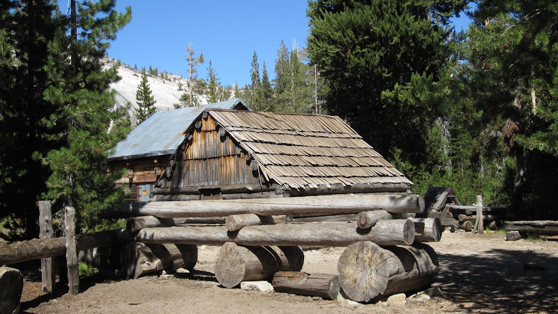
by balzaccom
Yellowhammer camp:
Re: Planning Southern Emigrant Trip June 15
Posted: Thu Jun 16, 2016 11:46 am
by Pietro257
I did a similar trip a couple of years ago (
http://highsierratopix.com/community/vi ... =1&t=11426). My two cents:
Camp Yellowhammer is well worth a visit. I prefer Big Lake to Pingree. There is a superb campsite at Big Lake on the west side with a beautiful view of the lake and a fire pit built such that you can recline on the rocks as you warm yourself by the fire -- a sort of chaise lounge arrangement. The nearby swimming hole is excellent too, as long as you are willing to jump the eight or ten feet off the rock to make use of it. Follow the use trail to find this campsite. All the other campsites I saw at Big Lake were soggy and mosquito-infested.
The chief feature of this area are the endless, polished, granite slabs. The large one between Pingree and Big Lake is called the Golden Staircase because it is stained brown by runoff.