Page 4 of 7
Re: Who owns this lake? Yosemite or Emigrant?
Posted: Sat Feb 13, 2016 8:04 am
by Hobbes
oldranger wrote:Key is the description of the boundary on the nw corner of the map: "Divide Between Cherry Creek and Eleanor and Falls Creeks".
But does the mystery lake drain into Kendrick which then becomes Eleanor? That would put the lake within the Yosemite side of the divide. I've looked closely at both aerial satellite views & flipped G-Earth over sideways, and as Daisy suggested, it looks like it could very well drain both ways.
If you zoom all the way in on the little round tarn just below the lake (sort of like Sicily by the boot of Italy), does it drain to the tarn right next to it (slightly to the NW)? Or is it just an upper catch basin for the main part of the lake which then drains to the NE when full?
It really seems like somebody (or a group like a meet-up) needs to go up there, pour about a liter of water on the ground between the two tarns and observe (and possibly film) which way the water flows.

Re: Who owns this lake? Yosemite or Emigrant?
Posted: Sun Feb 14, 2016 7:41 am
by kpeter
Hobbes wrote:oldranger wrote:Key is the description of the boundary on the nw corner of the map: "Divide Between Cherry Creek and Eleanor and Falls Creeks".
But does the mystery lake drain into Kendrick which then becomes Eleanor? That would put the lake within the Yosemite side of the divide. I've looked closely at both aerial satellite views & flipped G-Earth over sideways, and as Daisy suggested, it looks like it could very well drain both ways.
If you zoom all the way in on the little round tarn just below the lake (sort of like Sicily by the boot of Italy), does it drain to the tarn right next to it (slightly to the NW)? Or is it just an upper catch basin for the main part of the lake which then drains to the NE when full?
It really seems like somebody (or a group like a meet-up) needs to go up there, pour about a liter of water on the ground between the two tarns and observe (and possibly film) which way the water flows.
I concluded the same thing. It is not possible from the maps or Google Earth to figure out whether the surface drainage is to the NE or the SW or both. What is likely is that when snowmelt is at its peak there is surface drainage in both directions, and when snowmelt is over there is surface drainage in neither direction.
For the NE: There is haphazard jackstraw to the NE and a small, dry snowmelt pond. In the trapezoidal basin that butts up against the granite to the NE there is a low point more visible from Google Earth through which the water may drain, and possibly a fallen tree or granite berm that looks like it may be a kind of intermittent dam, and a sketchy line of bushes below. It looks like snowmelt accumulates in that NE area and seeps over the lip to the NE.
For the SW: The SW "Sicily" tarn is definitely connected to the main lake. One question is whether the SW "Sicily" tarn drains to its NW to the other "Corsica" tarn. I'm not sure it does. The granite between them looks pretty dry for that satellite pic. On the other hand, there is an inlet from the main lake that may connect to the Corsica tarn during snowmelt--there seems to be bare dirt and jackstraw rather than granite linking the inlet with Corsica. During heavy snowmelt that area would be inundated.
In just looking at vegetation, it is clear that there is more water coming down to the SW from Corsica than going to the NE from the main lake; this water feeds the tributaries of Fawn Lake and Kendrick Creek. See, for example, the inlet stream snaking into the tarns to the NW of Fawn Lake. It looks substantial in the satellite pics. I'd be inclined to take that as evidence that the bulk of the drainage goes SW to Kendrick--although it is probably more seepage than surface stream in the immediate vicinity of our lake.
Re: Who owns this lake? Yosemite or Emigrant?
Posted: Sun Feb 14, 2016 11:29 am
by gdurkee
This is pretty fun. Using Arc 10, I've got the Yosemite boundary shapefile which matches the ones that show the lakes as outside Yosemite. The legal description of 1905 is the key. The boundary is the divide between the two drainages. I think the cartographers who drew the most recent boundary got it right. Both a topo map and satellite imagery suggest they drew the boundary right along a granite rib which is the watershed boundary.
They may just have been compounding the error, but all of Yosemite's data (lakes, trails, elevation models, hillshade) are all clipped at that boundary. This also makes it difficult to tell for absolute sure because, at least with an elevation model, you could tell if they got it right but mine doesn't continue to the north.
Also, as far as Yosemite administration is concerned, the boundary they've drawn is what they've been managing. Which is also to say if you had a dog at that lake and somehow a ranger showed up (hah!), you'd have a good argument that it was allowed.
Still: A map is not the territory it represents, but if correct, it has a similar structure to the territory, which accounts for its usefulness.
Philosopher and scientist Alfred Korzybski, 1931
Re: Who owns this lake? Yosemite or Emigrant?
Posted: Sun Feb 14, 2016 11:55 am
by Wandering Daisy
"A map is not territory it represents" - how true. Unless they went out and surveyed with real survey equipment, the accuracy depends on the source of the data. DEM's or digital elevation models have accuracy limits. LANDSAT data is 30 meters. Most USGS maps are based on 30 meter accuracy data. If a feature is smaller than 30 meters, it could land on either side of a "line" which is also located with a 30 meter accuracy. In other words the map will not tell you! GPS accuracy has been improving, but it also has accuracy limits. One really needs to go out to that location and see with your own eyes, where the lake is located relative to the "ridge" that shows up on the map based on the DEM. Since you would need to determine the high point/ridge near the lake you would also need to bring a laser level. Now we all have a project! "The HST Community Lake Verification Program"!
Re: Who owns this lake? Yosemite or Emigrant?
Posted: Sun Feb 14, 2016 12:25 pm
by kpeter
The more I obsess over this, the more I think they got it right with the green line. That green line draws the boundary between the tarns we've named "Sicily" and "Corsica" for their positioning near the main lake, and if that is the division then everything else about the green line follows easily from that assumption. The green line had to have been drawn before satellite imagery got refined, no? It is a plausible line from recent, detailed satellite imagery but not particularly plausible from the contour maps alone. The only way that green line gets drawn is if someone was on the ground and determined that the watershed is divided between those two tarns.
Re: Who owns this lake? Yosemite or Emigrant?
Posted: Sun Feb 14, 2016 3:46 pm
by gdurkee
Nothing like a bright shiny object crossing my path... . I've got a 10m DEM which, of course, carries the same potential for error as the standard 30m, just less likely. Unfortunately, it's clipped at the park boundary. But, there's some hope this was flown for LIDAR after the Rim Fire. Depending on the resolution, that's likely sub-meter accuracy. (In one application, it was used to predict which way roads would drain and where to build or improve culverts following the fire.) LIDAR are huge files but I know one of the Yosemite GIS people. Maybe I can track that down.
The old topo maps were made using two terrain images, stereoplotters, special glasses and tracing the contour lines guiding the plotter by hand. I'd understood most of the plotter operators were women. You had to have incredible patience and depth perception to guide that puppy. When I started Forestry school (1969) we had stereoscopes in photogrammetry. I could never see the 3D effect and was constantly guessing. I think I passed, but not sure why. All that was gone within 10 years, I think. I don't know for sure, but it wouldn't surprise me that paper USGS maps into the 80s, at least, had the contours done by hand.
Re: Who owns this lake? Yosemite or Emigrant?
Posted: Sun Feb 14, 2016 4:00 pm
by gdurkee
Arrggghhhh! I love GIS. I found a profile tool for Arc. I started the line for the profile by the tarn just inside the park, then continued over where the current boundary shows, then down. The profile would indicate that's the watershed boundary though I suppose I should fiddle more. But I'm right in the middle of making profiteroles (under close, close supervision!). Now let's see if the embed code works...:
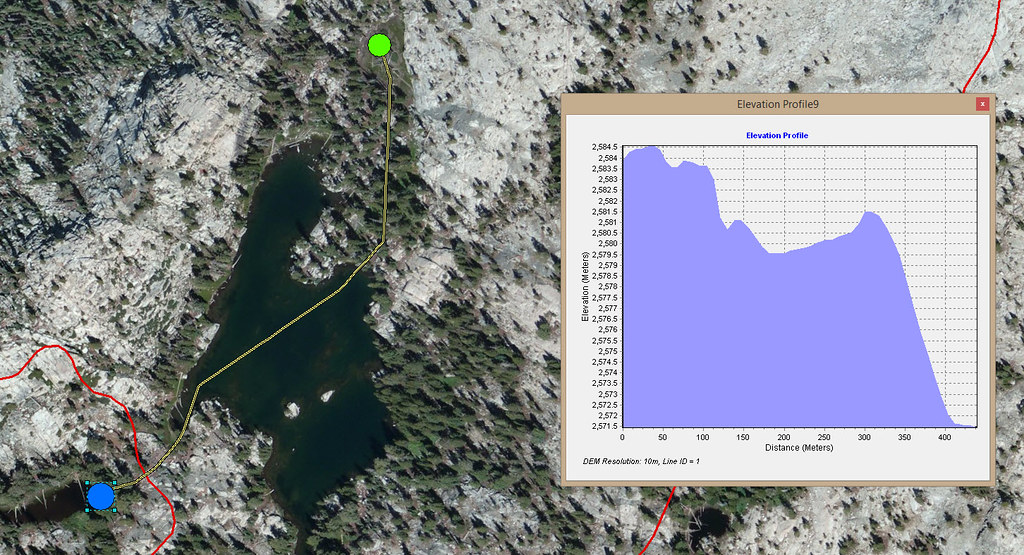 NorthYOSE_ElevProfile
 by
gdurkee, on Flickr
Re: Who owns this lake? Yosemite or Emigrant?
Posted: Sun Feb 14, 2016 4:05 pm
by rlown
gdurkee wrote:But I'm right in the middle of making profiteroles (under close, close supervision!)
And a happy Valentines Day to you as well.

All of you!! About to fire the steaks, and do the Asparagus.
Re: Who owns this lake? Yosemite or Emigrant?
Posted: Sun Feb 14, 2016 4:32 pm
by maverick
LIDAR are huge files but I know one of the Yosemite GIS people.
GD,
The Yosemite GIS specialist that worked on this was Vanessa Glynn-Linaris.
Re: Who owns this lake? Yosemite or Emigrant?
Posted: Sun Feb 14, 2016 7:25 pm
by oldranger
I expect since I found a boundary benchmark dated 1906 on an untrailed pass that the boundary was pretty carefully surveyed early on and that someone actually treaded the part of the boundary that is now in question back in 1905 or 06 and that is why it seems that Yosemite has pretty consistently excluded the lake in question. I wonder if there is documentation of the surveys that must have taken place back then. Somehow the idea of techies using maps and aerial or satellite photos to determine the boundary just seems wrong to me.
Mike