Who owns this lake? Yosemite or Emigrant?
-
kpeter

- Topix Fanatic
- Posts: 1449
- Joined: Mon Jan 04, 2010 1:11 pm
- Experience: Level 3 Backpacker
Re: Who owns this lake? Yosemite or Emigrant?
The more I obsess over this, the more I think they got it right with the green line. That green line draws the boundary between the tarns we've named "Sicily" and "Corsica" for their positioning near the main lake, and if that is the division then everything else about the green line follows easily from that assumption. The green line had to have been drawn before satellite imagery got refined, no? It is a plausible line from recent, detailed satellite imagery but not particularly plausible from the contour maps alone. The only way that green line gets drawn is if someone was on the ground and determined that the watershed is divided between those two tarns.
-
gdurkee

- Founding Member
- Posts: 774
- Joined: Tue Nov 08, 2005 8:20 pm
- Experience: N/A
Re: Who owns this lake? Yosemite or Emigrant?
Nothing like a bright shiny object crossing my path... . I've got a 10m DEM which, of course, carries the same potential for error as the standard 30m, just less likely. Unfortunately, it's clipped at the park boundary. But, there's some hope this was flown for LIDAR after the Rim Fire. Depending on the resolution, that's likely sub-meter accuracy. (In one application, it was used to predict which way roads would drain and where to build or improve culverts following the fire.) LIDAR are huge files but I know one of the Yosemite GIS people. Maybe I can track that down.
The old topo maps were made using two terrain images, stereoplotters, special glasses and tracing the contour lines guiding the plotter by hand. I'd understood most of the plotter operators were women. You had to have incredible patience and depth perception to guide that puppy. When I started Forestry school (1969) we had stereoscopes in photogrammetry. I could never see the 3D effect and was constantly guessing. I think I passed, but not sure why. All that was gone within 10 years, I think. I don't know for sure, but it wouldn't surprise me that paper USGS maps into the 80s, at least, had the contours done by hand.
The old topo maps were made using two terrain images, stereoplotters, special glasses and tracing the contour lines guiding the plotter by hand. I'd understood most of the plotter operators were women. You had to have incredible patience and depth perception to guide that puppy. When I started Forestry school (1969) we had stereoscopes in photogrammetry. I could never see the 3D effect and was constantly guessing. I think I passed, but not sure why. All that was gone within 10 years, I think. I don't know for sure, but it wouldn't surprise me that paper USGS maps into the 80s, at least, had the contours done by hand.
-
gdurkee
- Founding Member
- Posts: 774
- Joined: Tue Nov 08, 2005 8:20 pm
- Experience: N/A
Re: Who owns this lake? Yosemite or Emigrant?
Arrggghhhh! I love GIS. I found a profile tool for Arc. I started the line for the profile by the tarn just inside the park, then continued over where the current boundary shows, then down. The profile would indicate that's the watershed boundary though I suppose I should fiddle more. But I'm right in the middle of making profiteroles (under close, close supervision!). Now let's see if the embed code works...:
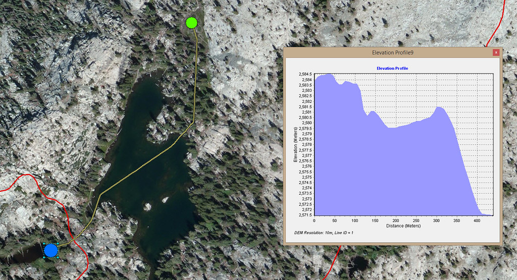 NorthYOSE_ElevProfile by gdurkee, on Flickr
NorthYOSE_ElevProfile by gdurkee, on Flickr-
rlown

- Topix Docent
- Posts: 8225
- Joined: Thu Oct 25, 2007 5:00 pm
- Experience: Level 4 Explorer
- Location: Wilton, CA
Re: Who owns this lake? Yosemite or Emigrant?
And a happy Valentines Day to you as well.gdurkee wrote:But I'm right in the middle of making profiteroles (under close, close supervision!)
-
maverick

- Forums Moderator

- Posts: 11834
- Joined: Thu Apr 06, 2006 5:54 pm
- Experience: Level 4 Explorer
Re: Who owns this lake? Yosemite or Emigrant?
LIDAR are huge files but I know one of the Yosemite GIS people.
GD,
The Yosemite GIS specialist that worked on this was Vanessa Glynn-Linaris.
Professional Sierra Landscape Photographer
I don't give out specific route information, my belief is that it takes away from the whole adventure spirit of a trip, if you need every inch planned out, you'll have to get that from someone else.
Have a safer backcountry experience by using the HST ReConn Form 2.0, named after Larry Conn, a HST member: http://reconn.org
-
oldranger

- Topix Addict
- Posts: 2861
- Joined: Fri Jan 19, 2007 9:18 pm
- Experience: N/A
- Location: Bend, Oregon
Re: Who owns this lake? Yosemite or Emigrant?
I expect since I found a boundary benchmark dated 1906 on an untrailed pass that the boundary was pretty carefully surveyed early on and that someone actually treaded the part of the boundary that is now in question back in 1905 or 06 and that is why it seems that Yosemite has pretty consistently excluded the lake in question. I wonder if there is documentation of the surveys that must have taken place back then. Somehow the idea of techies using maps and aerial or satellite photos to determine the boundary just seems wrong to me.
Mike
Mike
Mike
Who can't do everything he used to and what he can do takes a hell of a lot longer!
Who can't do everything he used to and what he can do takes a hell of a lot longer!
-
Wandering Daisy

- Topix Docent
- Posts: 6689
- Joined: Sun Jan 24, 2010 8:19 pm
- Experience: N/A
- Location: Fair Oaks CA (Sacramento area)
- Contact:
Re: Who owns this lake? Yosemite or Emigrant?
I totally agree Old Ranger! Maybe it is because we are of the same generation- back when people actually got out and put boots on the ground and surveyed! I have worked enough with GIS and satellite images (granted, in the days when they were less accurate) but still, you can produce absolutely exact looking profiles, drainages in spite of bad data.
I love Google Earth but I have looked at areas that I have been in and the land slope can look different than it really is. A DEM is a mathematically generated surface. Post-satellite 7.5 minute map contours look smoother because they are artificially smoothed, rather than the old method where a real cartographer drew the lines. Not that there was not a lot of "geographic license" used, but a good cartographer can depict the actual topography better than a computer. Back in the days when the government had money to do this. The "golden age" of USGS mapping was the 1960's-70's when the 7.5 minute maps were first being made. But, on the other hand the 1906 maps were likely 30-minute map which are so coarsely surveyed that they would simply miss such a small feature. I suspect that no park boundary would be based on a 30-minute map alone. I bet they DID survey it.
Another little twist here. Early 1900's was climatically different. We were coming out of the "little Ice Age" with its much colder, snowy winters. That shores of that lake were not likely in the same place as today. I bet the lake was larger.
-
Hobbes
- Topix Fanatic
- Posts: 1120
- Joined: Wed Apr 27, 2011 8:09 am
- Experience: N/A
- Location: The OC
Re: Who owns this lake? Yosemite or Emigrant?
I think they did as well. Which suggests a pretty cool situation where one could be standing within the few meters separating 'Corsica' & 'Sicily' to witness two different watershed sources + a Nat'l park boundary.Wandering Daisy wrote:I bet they DID survey it.
As an aside, since this is such a fun topic, I'm sure everyone is dying to know about key real property concepts like accretion, reliction & avulsion:
Accretion - the gradual increase or acquisition of land by the imperceptible action of natural forces washing up sand, soil, or silt from the water course
Reliction - gradual eroding or washing away
Any increase of soil or sand to land adjacent or contiguous to a water course formed by accretion becomes the possession of the riparian or littoral owner. Likewise, any erosion or reliction due to the gradual actions of nature become lands lost by the riparian or littoral owner.
Avulsion - By contrast, the sudden and perceptible change formed by nature is referred to avulsion. The violence of an event may suddenly change the flow or construction of a water course or the lands abutted. Unlike with accretion, land divided by avulsion remains the property of the original owner as if the water course had not been moved.
So, if common real estate law applies in this case, perhaps the Yose property could expand if Sicily began to slowly creep & drain into Corsica, so that after a period of years, it had developed a more pronounced drainage point. (Consider an underground seep constantly freezing, expanding & cracking the rock so that it actually formed a channel.)
OTOH, if there was an earthquake and the drainage was altered suddenly to form a channel/crevice between Sicily & Corsica, the old demarcation indicating drainage to the NE, thus outside of Yose boundaries, would be maintained.
Enjoy.
-
yosehiker
- Topix Acquainted
- Posts: 43
- Joined: Sun Jul 25, 2010 3:36 pm
- Experience: N/A
Re: Who owns this lake? Yosemite or Emigrant?
While I think that the boundary is still determined by the legal description and therefore the watershed boundary, I found this interesting old map showing the boundary change.
http://www.davidrumsey.com/luna/servlet ... ional-Park
http://www.davidrumsey.com/luna/servlet ... ional-Park
-
maverick
- Forums Moderator
- Posts: 11834
- Joined: Thu Apr 06, 2006 5:54 pm
- Experience: Level 4 Explorer
Re: Who owns this lake? Yosemite or Emigrant?
Hi Yosehiker,
Thanks, that map was already sent to the parties involved.
Thanks, that map was already sent to the parties involved.
Professional Sierra Landscape Photographer
I don't give out specific route information, my belief is that it takes away from the whole adventure spirit of a trip, if you need every inch planned out, you'll have to get that from someone else.
Have a safer backcountry experience by using the HST ReConn Form 2.0, named after Larry Conn, a HST member: http://reconn.org
I don't give out specific route information, my belief is that it takes away from the whole adventure spirit of a trip, if you need every inch planned out, you'll have to get that from someone else.
Have a safer backcountry experience by using the HST ReConn Form 2.0, named after Larry Conn, a HST member: http://reconn.org
Who is online
Users browsing this forum: No registered users and 51 guests