Enjoyed your images bluewater. And now I know what some of you look like as well as that remote basin.
Quite a superb balanced location for your reflection image, photo #4 below top.
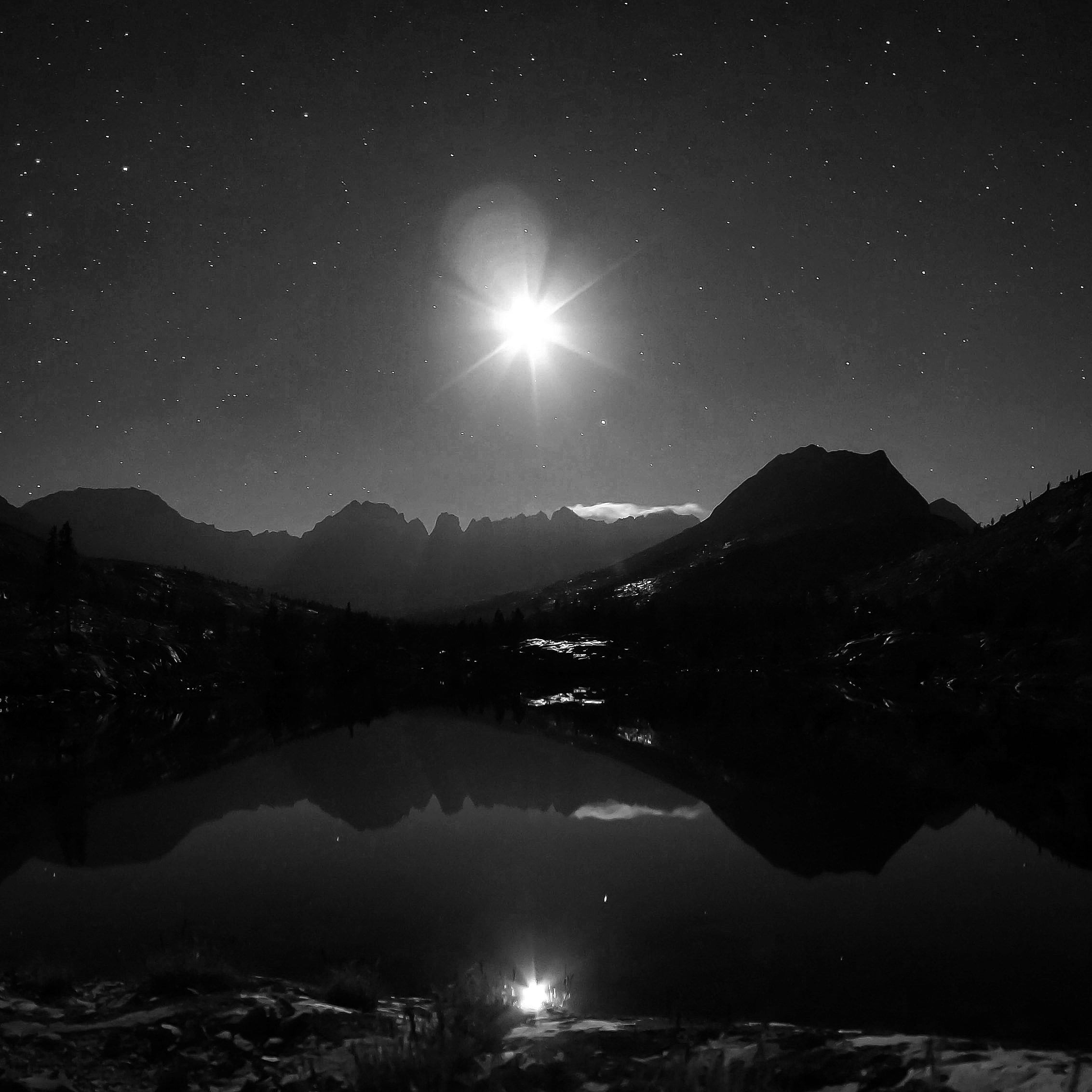
kaweah peaks reflection
With all the work I already have queued up in Upper Kern areas, when I finally manage to get over Shepherd once we get a normal wet greening winter, it will be tough to get anywhere near that more remote realm.
Do notice post processing halo artifacts around trees against the skies. Not something one would see right out of the camera. Some here ought to be able to offer some advice on how to avoid that. Would need to know what software was used.
David
TR: Maverick's 2015 Annual HST Meet-Up 7/22-7/24/15
-
SSSdave

- Topix Addict
- Posts: 3524
- Joined: Thu Nov 17, 2005 11:18 pm
- Experience: N/A
- Location: Silicon Valley
- Contact:
-
maverick

- Forums Moderator

- Posts: 11834
- Joined: Thu Apr 06, 2006 5:54 pm
- Experience: Level 4 Explorer
Re: Trip Report: Maverick's 2015 Annual HST Meet-Up 7/22-7/2
Ha, sent Andy a PM, about an hour ago, about exactly that issue.Do notice post processing halo artifacts around trees against the skies. Not something one would see right out of the camera. Some here ought to be able to offer some advice on how to avoid that. Would need to know what software was used.
Professional Sierra Landscape Photographer
I don't give out specific route information, my belief is that it takes away from the whole adventure spirit of a trip, if you need every inch planned out, you'll have to get that from someone else.
Have a safer backcountry experience by using the HST ReConn Form 2.0, named after Larry Conn, a HST member: http://reconn.org
-
oleander
- Topix Expert
- Posts: 480
- Joined: Wed Aug 18, 2010 10:15 am
- Experience: N/A
Re: Trip Report: Maverick's 2015 Annual HST Meet-Up 7/22-7/2
Which of the HST people who preceded us on Pyra Queen dumped your Bieber party favors there? Had to be MN2, Andre, or Gazelle!
-
Bluewater

- Topix Expert
- Posts: 584
- Joined: Sun Oct 23, 2011 3:33 pm
- Experience: Level 4 Explorer
- Location: Laguna Beach
- Contact:
Re: Trip Report: Maverick's 2015 Annual HST Meet-Up 7/22-7/2
Re the halo effects; I uploaded all of my photos onto a Picassa album and their latest software automatically sensed my triple exposure sets and created those HD photos (without my permission:). It also takes the obvious pano sets and creates panoramas and even some interesting GIFs out of multiple photos that were taken from the same point of view. I have been using some very basic HD software (Fusion) and was planning on doing the HD processing myself, but since these were created so quickly and automatically I just posted them. Any help you could offer regarding the strange halo effect around the trees (or any other help) would be very much appreciated. I am just an amateur using an old Canon S95. Here are two more that came out surprisingly well for an automated process, although very novice in comparison to the professional processing that you are probably used to seeing:
You do not have the required permissions to view the files attached to this post.
-
Hobbes
- Topix Fanatic
- Posts: 1120
- Joined: Wed Apr 27, 2011 8:09 am
- Experience: N/A
- Location: The OC
Re: Trip Report: Maverick's 2015 Annual HST Meet-Up 7/22-7/2
It's a hellahike. I've got it at 27.2 miles from Shepherd. Going over Whitney crest is actually about a mile longer and 1.3k higher. I believe Cottonwood/NAP/OAP are another 5+ miles; Richard can tell us. Not sure what the west side TH distances are, but mileage isn't the only factor from either east or west.schmalz wrote:Wow, I need to get into that basin. Incredible.
From Shepherd, there's the 6k climb (6->12), the 4k drop (12->8 @ Junction), the 2.8k climb (8->10.8) to Island, the 2.8k drop back to Junction, and then for desert, the 4k climb back to Shepherd, and the 6k drop down to the Symmes TH.
Looking back towards Shepherd pass from the outlet of Island lake. This photo provides the visual accompaniment to the numbers listed above. Shepherd is past the V formed between Kern point on the left, and the series of 14ers on the right: Tyndall, Willy & Barnard.

As far as crowds, except for a couple hikers on Shepherd going either way, I never saw anyone on the LSA/Kern/Colby trails - nada, no one. It's only on the JMT/HST that you'll see anyone.
So if you want to push yourself to maximum physical effort, and be all alone to boot, then it's a wonderful hike. Just give yourself an extra day in between to kick-back, explore a bit and take some photos:

-
schmalz
- Topix Expert
- Posts: 588
- Joined: Fri May 07, 2010 9:18 am
- Experience: Level 4 Explorer
- Location: Altadena, CA
- Contact:
Re: Maverick's 2015 Annual HST Meet-Up 7/22-7/24/15
Yeah, that's the plan. I might try a westside approach whenever I get around to it. I was supposed to go up there on my Circle of Solitude trip 3 years ago but by that point of the trip I didn't feel up to it, and my tripod was broken, so I skipped it and Milestone Basin. 
It might another decade until I get back.
It might another decade until I get back.
http://CaliTrails.com" onclick="window.open(this.href);return false;
http://facebook.com/calitrails" onclick="window.open(this.href);return false;
http://facebook.com/calitrails" onclick="window.open(this.href);return false;
-
richlong8
- Topix Expert
- Posts: 839
- Joined: Tue Nov 25, 2008 6:02 pm
- Experience: Level 4 Explorer
Re: TR: Maverick's 2015 Annual HST Meet-Up 7/22-7/24/15
Wow, I am enjoying the photos and information. Even better when you have a meetup, then going alone. I hope to post tomorrow froe trip.I have most of the text written, and am trying to get a few photos shrunk down a bit for HST
-
MN2CAPisco
- Topix Acquainted
- Posts: 39
- Joined: Tue Mar 18, 2014 10:36 pm
- Experience: Level 4 Explorer
Re: Trip Report: Maverick's 2015 Annual HST Meet-Up 7/22-7/2
Since Andrey doesn't have an account here I say we blame him. He's also well known for his less than adult musical preferences, so the shoe fits.oleander wrote:Which of the HST people who preceded us on Pyra Queen dumped your Bieber party favors there? Had to be MN2, Andre, or Gazelle!
Personally, I found the basin more reminiscent of Beethoven than Bieber, especially around peaceful Island Lake after all you kids went to bed:
-
MN2CAPisco
- Topix Acquainted
- Posts: 39
- Joined: Tue Mar 18, 2014 10:36 pm
- Experience: Level 4 Explorer
Re: Trip Report: Maverick's 2015 Annual HST Meet-Up 7/22-7/2
I've got the trip from Wolverton via the High Sierra Trail to Nine Lakes Basin/PQC at ~25.1 miles, about 17.8 of those miles on trail until you break off toward the heart shaped lake. I'm guessing a Mineral King start would be even less mileage, but like you mention mileage isn't the only difficulty, I show 11,092' of gain and 7849' of loss our route to Island Lake given the ups and downs along the way.Hobbes wrote: Not sure what the west side TH distances are, but mileage isn't the only factor from either east or west.
-
Wandering Daisy
- Topix Docent
- Posts: 6689
- Joined: Sun Jan 24, 2010 8:19 pm
- Experience: N/A
- Location: Fair Oaks CA (Sacramento area)
- Contact:
Re: TR: Maverick's 2015 Annual HST Meet-Up 7/22-7/24/15
Sorry I missed almost everyone. I delayed two days, driving down and starting Monday. Peaks were under clouds when I arrived at Keweah Gap, and after two days with serious rain, I was really worried about slope stability on either Pants Pass of Pyra Queen, so I decided it would be a better bet to take the High Sierra Trail to Junction Meadow -100% chance of getting there BUT- LONG detour -two 14-mile days- Hamilton Lake to Moraine Lake and then Moraine Lake to Junction Meadow. I did not have maps so only remembered that I had done it before in 2 days. At least I got to see Jimr at junction meadow. I got to Island Lake about 3PM on the 24th. Did a nice day hike to the upper basin next day and then camped at the lowest Picket Lake (caught lots of fish). Then out over Colby Pass to Colby Lake (again caught LOTS of fish). Then up Cloud Canyon. I must have messed up but when I got to what I thought was Copper Mine Pass, it was just too hard to do with a pack, so I backed off and went over Lion Lake/Lion Rock passes and camped in Nine Lakes Basin (caught LOTS of fish). Then yesterday I actually walked all the way out  over 20 miles - did it in 11 hours. Drove home toady. I will get an actual trip report out when I get photos processed.
Who is online
Users browsing this forum: Bing [Bot], mkbgdns and 83 guests