Yes, Goddard Creek above the confluence of Disappearing Creek is "paradise" compared to Enchanted Gorge and especially the lower Goddard Creek Section. Its much easier walking that takes you back towards Lake 10232. I also second that Arnot must have done the route when he could criss cross this section in a low snow year or in the fall. This makes the route much more navigable when obstacles arise; just cross the river or walk in it. When I went down it in 2011, that was my strategy as I have used this to get down say, the Muro Blanco and other river routes overgrown with alders and such. Boy was I in for a surprise when this wasn't possible. Also, as others stated above, once you get into the Gorge, it kinda sucks to think about turning around and retracing steps if you had to. My partner and I had some of the same thoughts, especially when we had to climb up a "class 4" grass and rock cliff band with a class 5 move to gain a ramp system 300ft above the creek as we were committed to the right side of the creek heading down. There was no way we wanted to repeat those moves. There was another section of fresh rockfall below the confluence of Disappearing Creek and Goddard Creek on the right side that was somewhat precarious walking over it. And before dropping into Simpson Meadow, if someone is on the right side and gets hung up in the willows and decides to drop down to the creek, there is a cascade that was also very risky when trying to circumnavigate around as a fall into the water would have been deadly. I have a really good friend and previous roommate who has done this route as well, however he said he did it in the Fall when the water was low and there wasn't any trouble. He laughed when I told him about my birthday trip.
I also forgot about the crossing at Simpson Meadow as well until Wandering Daisy mentioned it..... We crossed on August 29th and the river was barely doable. It was scariest crossing I have done. And I have crossed rivers in Alaska. The water was still incredibly high and powerful at the safest place. We lost a camera in the process and swam the last section. We met a couple other hikers coming from the confluence of Palisade Creek who expressed that they couldn't even ford that crossing onto the JMT and that they had been searching for a log crossing. They were average experienced hikers. When we reached the ford, it was 1/4 as bad as the Middle Kings at Simpson. People could potentially become stuck at the mouth of Lower Goddard with no way to go but down towards Tehipite Valley in this case. Just food for thought as well.
All in all, as delightful as this route may be in the Gorge in the lowest of the two previous snow years, I believe it would be truly the opposite in an average to above average snow year, unless later towards September. I myself enjoy going to these wild places in this range I call home. However, I would have some apprehension repeating my route unless I was skipping that lower section. I would probably go down the outlet of Tunemah, down into Goddard Creek and across to climb up to Wheel Mountain and Devils Crags to drop over down to Rambaud Lakes.
Kings Canyon High Basin Route
-
jenreyn

- Topix Acquainted
- Posts: 51
- Joined: Wed Jul 31, 2013 12:37 pm
- Experience: Level 4 Explorer
-
Bluewater

- Topix Expert
- Posts: 584
- Joined: Sun Oct 23, 2011 3:33 pm
- Experience: Level 4 Explorer
- Location: Laguna Beach
- Contact:
Re: Kings Canyon High Basin Route
"Will be taking a 5 day break from this thread in about 10 minutes.
I really did not find EG to be as terrible as everyone says. Not easy and hard enough to make looking at alternates worthwhile, but not something that cannot be part of such a l a route.
The only section of the route I have not done is Bubbs to Woods. Pre Edition explains such and alternate route given, though this appears to be a straightforward section -- Gardiner Pass and then King Col.
The climb from Woods to Arrow can be rough if you do not pick the right ascent path. I have been over White Fork Pass too but overall I like Arrow better. Explorer Pass is another option but I have not been over it yet".
Thank you for the additional information about the climb from Woods to Arrow.
-
SweetSierra

- Topix Regular
- Posts: 303
- Joined: Mon May 16, 2011 12:23 pm
- Experience: Level 4 Explorer
- Location: Tucson, Arizona
Re: Kings Canyon High Basin Route
The thought I had about the route was the same as Wandering Daisy mentioned. Roper's High Route was created and advertised as a Class 2 route that an average hiker could manage. Calling this a "High Route" may seem to many to be the same kind of route, if they don't read any qualifiers too closely, just because Roper's "High Route" is so well known. I like the Kings Canyon High Route idea, just had a thought about perception. Copper Mine Pass isn't difficult and I thought it was a thrill to find the old miner's trail at the top, but it's not easy to find from Glacier Lake. In a guide, though, specific markers (like Roper's) would help quite a bit in locating it.
Last edited by SweetSierra on Wed Apr 15, 2015 6:21 am, edited 2 times in total.
-
RoguePhotonic

- Topix Fanatic
- Posts: 1693
- Joined: Thu Mar 24, 2011 9:52 am
- Experience: Level 4 Explorer
- Location: Bakersfield CA
- Contact:
Re: Kings Canyon High Basin Route
Although Gardiner is easy enough there is nothing straight forward about King Col other than getting to the top from the West. It's the sort of pass that after I did it I wont ever do it again and as I noted in my write up of it I don't recommend anyone else do so either.though this appears to be a straightforward section -- Gardiner Pass and then King Col.
From a guide stand point this certainly can be a blocking point. King Col with any sort of cornice would be impassable without ropes. It's just too narrow and steep.
-
RoguePhotonic
- Topix Fanatic
- Posts: 1693
- Joined: Thu Mar 24, 2011 9:52 am
- Experience: Level 4 Explorer
- Location: Bakersfield CA
- Contact:
Re: Kings Canyon High Basin Route
Pure hell awaits youI would probably go down the outlet of Tunemah, down into Goddard Creek and across to climb up to Wheel Mountain and Devils Crags to drop over down to Rambaud Lakes.
If you do begin up Rambaud Pass from down there just begin up on the South side of the drainage that comes down. Trying to angle up before the brush gets too bad in Goddard Creek is a mistake. The hillside is horribly steep and covered in scrub oak.
Are you looking for info for the route going up Arrow Creek or the route noted here. I have done that route. The hump that is Arrow Descent 1 is an easy class 2 hop over. The terrain is also mostly grassy terrain from there to Descent 2. I dropped down the West side of that drainage all the way. It was plenty steep, over grown in sections having me climbing through White Thorn and Prickly Currants. Several sections narrow through slabs of granite that become very specific and steep at times. I eventually just before hitting the major section of burn zone was routed into a class 4-5 down climb on a single crack that was on the scary side. I could not see another option as the whole area around me was steep granite slabs with micro cliffs. I think perhaps I took the wrong way completely. I knew nothing more than people drop down there so I just went for it.Thank you for the additional information about the climb from Woods to Arrow.
I do believe that following the creek is impossible and the nature of the terrain pretty much makes you choose one side and stick with it because your not crossing over!
-
ndpanda
- Topix Acquainted
- Posts: 21
- Joined: Thu May 05, 2011 10:07 pm
- Experience: N/A
- Location: Lundy Canyon
Re: Kings Canyon High Basin Route
Crossing King Col at the beginning of August 2010 we carried and used ice axes and were forced into some step-cutting below the top of the chute in lieu of the belays we would have preferred. It's a treacherous angle up there and it really felt like we were pushing our luck. I don't have my copy of Secor handy but I'm pretty sure it's just described as garden variety Class 2. Technically true I suppose but exposure-wise I would question it—not so much for the airiness per se but for how far you'd likely fall if you slipped.RoguePhotonic wrote:
King Col with any sort of cornice would be impassable without ropes. It's just too narrow and steep.
-
RoguePhotonic
- Topix Fanatic
- Posts: 1693
- Joined: Thu Mar 24, 2011 9:52 am
- Experience: Level 4 Explorer
- Location: Bakersfield CA
- Contact:
Re: Kings Canyon High Basin Route
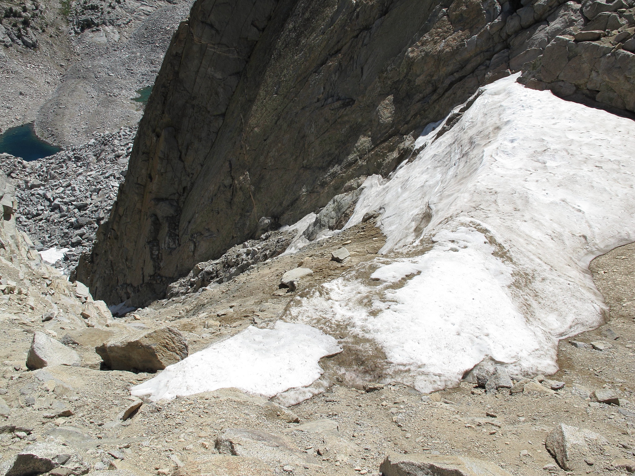
Photos are notorious for making things look like they are not a problem at all. Even in photos Kings Col looks steep as hell:
-
schmalz
- Topix Expert
- Posts: 588
- Joined: Fri May 07, 2010 9:18 am
- Experience: Level 4 Explorer
- Location: Altadena, CA
- Contact:
Re: Kings Canyon High Basin Route
This thread has definitely brought up a number of ethical concerns regarding online trip reports.
"The only section of the route I have not done is Bubbs to Woods. Pre Edition explains such and alternate route given, though this appears to be a straightforward section -- Gardiner Pass and then King Col."
I find this comment to be particularly disturbing in light of the fact that you are charging money for the guide to this route.
http://CaliTrails.com" onclick="window.open(this.href);return false;
http://facebook.com/calitrails" onclick="window.open(this.href);return false;
http://facebook.com/calitrails" onclick="window.open(this.href);return false;
-
Bluewater
- Topix Expert
- Posts: 584
- Joined: Sun Oct 23, 2011 3:33 pm
- Experience: Level 4 Explorer
- Location: Laguna Beach
- Contact:
Re: Kings Canyon High Basin Route
Thanks Rogue for your detailed description and map of the route from Woods to Arrow Basin. I was hoping for more details of the route and I appreciate that you are so open to sharing your experience.
From everything else that I've read your route seems to be the preferred way. I was surprised to see the route in Skurkas pre-edition follow a different line up from Woods (to the west apparently climbing the steep chutes) then contouring at about 3,000 meters to the west side of the ridge and leading up from there to the main section of the basin. In my back and forth emails with Tom K over the past month about this area he seems to favor a route more like yours.
Sent from my iPad using Tapatalk
-
Bluewater
- Topix Expert
- Posts: 584
- Joined: Sun Oct 23, 2011 3:33 pm
- Experience: Level 4 Explorer
- Location: Laguna Beach
- Contact:
Kings Canyon High Basin Route
". . though this appears to be a straightforward section -- Gardiner Pass and then King Col".
"Although Gardiner is easy enough there is nothing straight forward about King Col other than getting to the top from the West. It's the sort of pass that after I did it I wont ever do it again and as I noted in my write up of it I don't recommend anyone else do so either.
From a guide stand point this certainly can be a blocking point. King Col with any sort of cornice would be impassable without ropes. It's just too narrow and steep".
Thanks for sharing your first hand experience and photo of Kings Col. Based on this I don't think I will be following the KCHBR through Gardiner Basin!
Sent from my iPad using Tapatalk
Who is online
Users browsing this forum: natural lefty and 81 guests