Page 1 of 1
Mammoth to Yosemite Valley via the SHR
Posted: Sat Mar 07, 2015 10:25 pm
by ksenn
First post, been lurking for a loooong time, absorbing all the great info on here. I did a few searches but couldn't find much on this question.
About my experience:
Consider myself a Level 4 backpacker. Recently, I've done a lot of cross country day hikes in Anza Borrego trying to complete the SDC 100 list. Last year I did a section of the SHR from Piute Pass through Second Recess and out Mono Pass.
Comfortable on easy Class 3 as I'm usually solo, carrying a SPOT, but not looking to push my luck. No experience w/ ice axe or crampons.
My Question:
I'm planning a trip in late July from Mammoth to the valley on the SHR until the Lyell Fork area, then pick up the trail down to the valley. My current idea is to descend the slope between Foerester Creek and the Lyell Fork down to Triple Peak Fork, ford that and pick up the trail on the west side. That descent looks pretty slabby on Google Earth, just not sure if it's too steep to hike down and not sure what to expect at the river crossing. Anyone ever been down that slope and crossed that fork of the river around there?
Also thinking about taking a day to go up Ritter from the upper Ritter lake if anyone has ever done that and wants to share a horror or success story.
Thanks!
Here's a CalTopo link. Proposed route in red and orange.
http://caltopo.com/map?id=6J0P
edited to fix a bunch of typos
Re: Mammoth to Yosemite Valley via the SHR
Posted: Sun Mar 08, 2015 12:41 pm
by maverick
Hi Ksenn,
Welcome to HST! Here is a TR of that section of the SHR going north to south:
viewtopic.php?f=1&t=5461&hilit=Sierra+High+Route
PS Something is going on with the spacing between my words.
Re: Mammoth to Yosemite Valley via the SHR
Posted: Sun Mar 08, 2015 4:37 pm
by Wandering Daisy
I am not sure if this is what you mean, but I have descended the Lyell Fork between the two trails. I did it in the Fall and I recall that I needed to cross between sides of the creek to find a feasible route. Not sure it would go early in the year when water was higher. It was typical class 2-3 slab with some sections of bushwhacking. I had a light pack since I did it on a 3-day trip. You do have to be a good route-finder. I have rock climbed for many years so I did not think it was too bad. I have also descended Tenaya Canyon, which was harder. There were some exposed sections. I guess the difficulty would depend on your rock climbing experience. If you do not feel comfortable descending Stately Pleasure Dome in Tuolumne, you probably would not like the Lyell Fork descent.
Re: Mammoth to Yosemite Valley via the SHR
Posted: Sun Mar 08, 2015 10:40 pm
by seanr
ksenn wrote:
Also thinking about taking a day to go up Ritter from the upper Ritter lake if anyone has ever done that and wants to share a horror or success story.
Here's a CalTopo link. Proposed route in red and orange.
http://caltopo.com/map?id=6J0P
Last September I did a loop hike from Agnew Meadows, around Thousand Island Lake, over North Glacier Pass to Lake Catherine, past the Ritter Lakes, up the west slope of Ritter, and down the SE Glacier Route to Ediza and Shadow Lakes to return to my vehicle. By following the description below, I found going up the West Slope Route easy and no more than class 2:
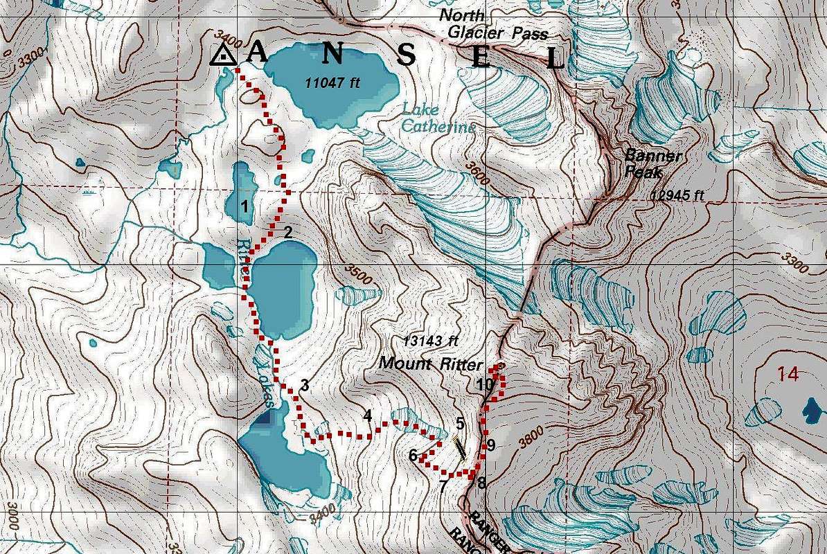 http://www.summitpost.org/mt-ritter-wes ... 8/c-438342
http://www.summitpost.org/west-slope/438342
http://www.summitpost.org/mt-ritter-wes ... 8/c-438342
http://www.summitpost.org/west-slope/438342
As noted by the author/xharv, it is easy to find yourself in class 4/5 terrain if you don't stay on route. I wouldn't want to go down the west slope without scouting the route by going up it first. The talus was pretty stable and much less sloggy/loose than the SE Glacier Route under the dry conditions I experienced.
Re: Mammoth to Yosemite Valley via the SHR
Posted: Mon Mar 09, 2015 10:54 am
by Pietro257
I did a route similar to this twice, once in 1998 and again in 2005. We went from Thousand Islands Lake to No. Glacier Pass, around Lake Catherine, down to Twin Island Lakes, to Bench Canyon, over Blue Lake Pass, down to the trail that leads into the Lyle Fork, from the Lyle Fork we went downhill to Yosemite Valley (where we caught the Amtrak bus and train to San Francisco).
It was a great trip both times. Roper in his book describes how to get from Lake Catherine to Twin Lakes, to Bench Canyon, and over Blue Lake Pass. From the top of that pass you can see where you have to go to pick up the trail down to the Lyle Fork.
Re: Mammoth to Yosemite Valley via the SHR
Posted: Mon Mar 09, 2015 11:22 am
by markskor
Just a thought, (see TOPO) after Blue Lake area - nice BTW - follow the cirque south-west towards Rockbound and then west, heading over the easy, obvious, (un-named) pass, crossing over just north of Long Mountain - exits above the Harriets, and then down to the Merced.
Re: Mammoth to Yosemite Valley via the SHR
Posted: Tue Mar 24, 2015 11:47 pm
by wildhiker
Not only is it easier to stay on the High Trail from the Forster Lake area all the way to Lewis Creek, but it has an absolutely stupendous view of the Clark Range as you climb out from the Lyell Fork to its north rim. The best viewpoint is about where the "Y" in Yosemite shows on your Caltopo map. West of that you are mostly in the forest but the trail is fast. The Merced River and its canyon above Merced Lake is pleasant but not that exciting in my opinion. I would use the High Trail rather than your x-c route down to the Merced River.
-Phil
Re: Mammoth to Yosemite Valley via the SHR
Posted: Sat Jul 01, 2017 1:45 pm
by Sebastian_A_K
Sean,
Did you cross Ritter with a multi-day pack or was this a long dayhike? Thinking about doing the same this year, but it sure won't be the same as in that September, with all the snow now.
Re: Mammoth to Yosemite Valley via the SHR
Posted: Sat Jul 01, 2017 1:52 pm
by Wandering Daisy
The original post is 2 years old- doubt if he/she will answer your question. Nevertheless, thanks for the added information on Mt. Ritter.