TR: Alger Lakes, Koip and Kuna Peaks 7/24-7/27
Posted: Mon Sep 01, 2014 12:47 pm
This is the standard on-trail route from Yosemite's Mono Pass trailhead to Alger Lakes with an excursion to Koip and Kuna Peaks.
Map of route using Gmap4

From the trailhead along Tioga Road, my brother and I hiked through Dana Meadows towards Parker Pass and avoided the forks to both Spillway Lake and Mono Pass. We gradually ascended as Koip Peak peeked over the Kuna Crest foreground.

Continuing through a pleasant meadow with patches of late blooming wildflowers, we arrived at diminutive Parker Pass (compare Parker Pass to Koip Peak Pass!), the boundary between Yosemite and Ansel Adams Wilderness. Since Yosemite regulations prohibit camping in the Parker Pass Creek watershed, legal camping was not available to us until we crossed this border. We surveyed ahead for a possible campsite and settled at one of the Parker Ponds just over the hill to the left.
View from Parker Pass
Campsite at Parker Ponds

The next day, we were back on the trail, passing more of the Parker Ponds and spotting a beautiful glacial melt-filled lake. Even in this drought year, we had to carefully cross over fast flowing cascading falls that fed the creamy blue lake below. Shortly thereafter, serious climbing up the north face of Parker Peak began. Initially, the trail went straight up so the incline required effort. As the mountain got even steeper, the trail turned to switchbacks. The entire mountain seemed to be a +12000’ scree pile of slate.
Parker Peak's north side
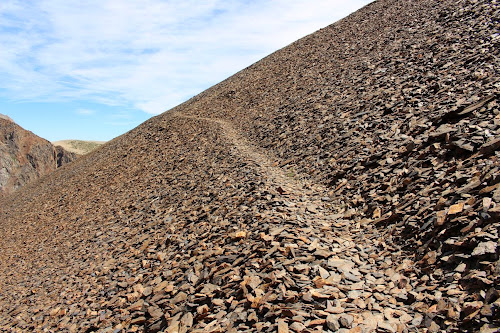
On the trail to Koip Peak Pass

Switchbacks

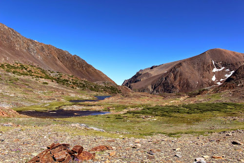
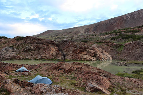
Furthermore, a fierce northeasterly wind was intent on keeping us from Koip Peak Pass. Finally at the pass, we sized up Koip Peak for the following day’s ascent before continuing down the south side of the pass, seeking relief from the wind. Halfway down, we had lunch on a soft patch of grass with views of the Alger Lakes and June Mountain ski resort. We ended our hike at the northern Alger Lake below Blacktop Peak. Having trouble finding a good wind-sheltered spot for our tents, we opted for just a scenic spot of which the choices were endless. This would also be a good test for both my new tent and my tent pitching skills. Noise from the loud flapping kept me awake most of the night but my tent survived and I had increased confidence in its sturdiness.
Northernmost Alger Lakes
Alger Lakes

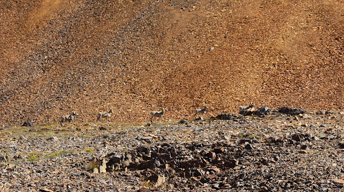
The next day could not have started any better. Halfway back up to Koip Peak Pass, we spotted a flock of Big Horn sheep, an encounter I had always hoped for but never expected. Wary of our presence, the flock moved away up the south face of Parker Peak. Energized by this rare sighting, we continued towards our first milestone of the day, Koip Peak.
Big Horn sheep
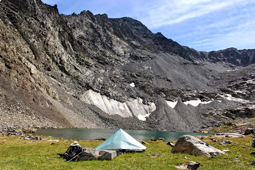
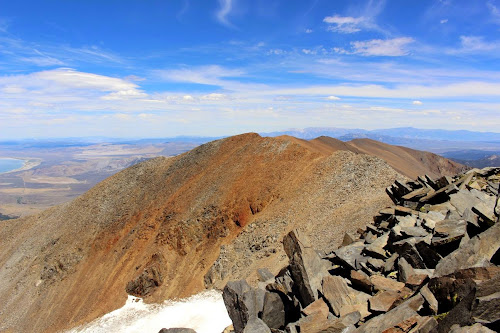
Fortunately, it was not as windy as yesterday. At the base of Koip Peak, we dropped our backpacks, removed our bear canisters, strapped on our daypacks and began the ascent, following traces of a use trail up the loose scree. We congratulated each other at the summit and I then set my target for Kuna Peak, the third highest peak in Yosemite. The route looked straightforward so I set off, traveling along the ridgeline. My brother decided to stay at Koip. I enjoyed the views from the ridge but then traveled slightly north of it until I reached the saddle between the peaks, site of a plane propeller. I then made my way up the eastern side of Kuna Peak, choosing a route requiring the use of my hands. 40 minutes after leaving Koip Peak, I arrived at the Kuna Peak summit where razor sharp jagged rocks were sticking up everywhere. I enjoyed the views, took pictures, and looked back at the speck on top of Koip Peak which was my brother. I returned to Koip Peak where we took a few more pictures and then began the long descent back to the Parker Pond area. We settled at the beautiful glacial lake we had seen previously before heading home the next day.
View of Alger Lakes from route to Koip Peak

Koip Peak from Kuna Peak
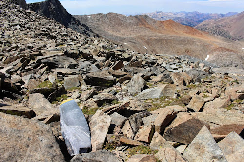
Propeller from an unlucky plane
Parker Pond
Smoke from a Yosemite fire

Panorama from Kuna Peak - smoke from fire is right of center

Map of route using Gmap4
From the trailhead along Tioga Road, my brother and I hiked through Dana Meadows towards Parker Pass and avoided the forks to both Spillway Lake and Mono Pass. We gradually ascended as Koip Peak peeked over the Kuna Crest foreground.
Continuing through a pleasant meadow with patches of late blooming wildflowers, we arrived at diminutive Parker Pass (compare Parker Pass to Koip Peak Pass!), the boundary between Yosemite and Ansel Adams Wilderness. Since Yosemite regulations prohibit camping in the Parker Pass Creek watershed, legal camping was not available to us until we crossed this border. We surveyed ahead for a possible campsite and settled at one of the Parker Ponds just over the hill to the left.
View from Parker Pass
Campsite at Parker Ponds
The next day, we were back on the trail, passing more of the Parker Ponds and spotting a beautiful glacial melt-filled lake. Even in this drought year, we had to carefully cross over fast flowing cascading falls that fed the creamy blue lake below. Shortly thereafter, serious climbing up the north face of Parker Peak began. Initially, the trail went straight up so the incline required effort. As the mountain got even steeper, the trail turned to switchbacks. The entire mountain seemed to be a +12000’ scree pile of slate.
Parker Peak's north side
On the trail to Koip Peak Pass
Switchbacks
Furthermore, a fierce northeasterly wind was intent on keeping us from Koip Peak Pass. Finally at the pass, we sized up Koip Peak for the following day’s ascent before continuing down the south side of the pass, seeking relief from the wind. Halfway down, we had lunch on a soft patch of grass with views of the Alger Lakes and June Mountain ski resort. We ended our hike at the northern Alger Lake below Blacktop Peak. Having trouble finding a good wind-sheltered spot for our tents, we opted for just a scenic spot of which the choices were endless. This would also be a good test for both my new tent and my tent pitching skills. Noise from the loud flapping kept me awake most of the night but my tent survived and I had increased confidence in its sturdiness.
Northernmost Alger Lakes
Alger Lakes
The next day could not have started any better. Halfway back up to Koip Peak Pass, we spotted a flock of Big Horn sheep, an encounter I had always hoped for but never expected. Wary of our presence, the flock moved away up the south face of Parker Peak. Energized by this rare sighting, we continued towards our first milestone of the day, Koip Peak.
Big Horn sheep
Fortunately, it was not as windy as yesterday. At the base of Koip Peak, we dropped our backpacks, removed our bear canisters, strapped on our daypacks and began the ascent, following traces of a use trail up the loose scree. We congratulated each other at the summit and I then set my target for Kuna Peak, the third highest peak in Yosemite. The route looked straightforward so I set off, traveling along the ridgeline. My brother decided to stay at Koip. I enjoyed the views from the ridge but then traveled slightly north of it until I reached the saddle between the peaks, site of a plane propeller. I then made my way up the eastern side of Kuna Peak, choosing a route requiring the use of my hands. 40 minutes after leaving Koip Peak, I arrived at the Kuna Peak summit where razor sharp jagged rocks were sticking up everywhere. I enjoyed the views, took pictures, and looked back at the speck on top of Koip Peak which was my brother. I returned to Koip Peak where we took a few more pictures and then began the long descent back to the Parker Pond area. We settled at the beautiful glacial lake we had seen previously before heading home the next day.
View of Alger Lakes from route to Koip Peak
Koip Peak from Kuna Peak
Propeller from an unlucky plane
Parker Pond
Smoke from a Yosemite fire
Panorama from Kuna Peak - smoke from fire is right of center
