Page 2 of 3
Re: Emigrant Wilderness Route Planning
Posted: Wed May 21, 2014 9:04 pm
by paul
For WD - I have been to Toejam, Leopold & Y Meadow Lakes - all very nice camping spots. Toejam seems to me likely to be the breeziest - but also maybe more meadow than at Y meadow (go figure that) lots of granite slabs around Y meadow. I would expect all to be skeeter city at that time.
My favorite is Pinto Lakes.
Can't comment on the fishing at any of those as I don't fish, and I haven't been to any of those with comrades who do.
Re: Emigrant Wilderness Route Planning
Posted: Wed May 21, 2014 9:32 pm
by jmyers
rlown wrote:jmyers wrote:If you want fish, don't go to wire lakes. I tried there for a couple hours without a single nibble in perfect conditions. I failed at Long as well, but it was snowing and and very windy so I wouldn't count it out just yet.
What were you fishing with? which lakes? connecting streams? when? sorry for so many questions, i loved that area..
Russ
I was fishing with an assortment of lures, but can't remember what kind. It was last October so the streams were all dried up. I fished upper wire, long lake and deer lake. I had success on Deer lake, but just small guys, max 10 in. Still great fun in a beautiful place
Re: Emigrant Wilderness Route Planning
Posted: Thu May 22, 2014 11:44 am
by FeetFirst
I've enjoyed peaceful camping and good fishing at Long Lake:

Looking NE across Long Lake from the west shore.
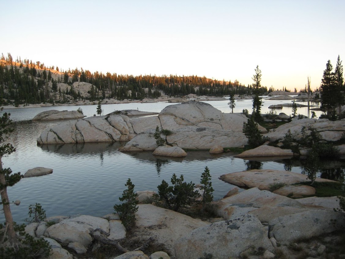
Looking SE across Long Lake from the west shore.
Fishing was slower at Y-Meadow Lake, but still decent. Plenty of secluded granite sites abound and the "sandy" (decomposed granite) shore and cool waters felt good on my tired feet:

Looking SW towards the outlet from the NE shore of Y-Meadow Lake.

Looking west from the NE shore of Y-Meadow Lake.
Emigrant Wilderness Route Planning
Posted: Tue May 27, 2014 2:29 pm
by Goshawk
Went a different time of year 2 years ago. Emigrant Lake very memorable--we did it as 16 mile day hike from Gem Lake which isn't on your route but a nice small lake for camping/swimming--I believe 9.5 miles in from another trailhead along 108. We fished in Deer Lake (no luck) one lazy day, not as good for swimming as some others. We bagged a peak by Deer Lake and had very nice view of Long Lake I think (mentioned above), and were unfortunately out of time to explore it, but it looked really nice. We had good intel from people camped at Buck's Lake that they had really nice fishing by using the local bugs as lures.
Overall a very nice loop and there seem to be a lot of possible combinations for 4-5 days out there. There were a couple of so so stretches on first day, but elevation change very civilized, and once you're up there it's pretty great.
Sent from my iPad using Tapatalk
Re: Emigrant Wilderness Route Planning
Posted: Wed May 28, 2014 10:15 am
by jhoest
First of all, thanks everyone for all the info. Based upon a few members suggestions, sounds like the creek crossings at various locations might make for some challenges on the route I initially planned, so sounds like the Gianelli trailhead might be a better bet than starting from Crabtree, and still gets me to where I would hopefully like to go.
I should have a good trip report for when I get back. Thanks again!
Re: Emigrant Wilderness Route Planning
Posted: Thu May 29, 2014 7:57 am
by Wandering Daisy
I called the FS yesterday and you have to park on the road and walk the last half mile to Gienelli. I decided to still go in Crabtree, to Bear Lake and x-c up to Granite Lake. This gets me the same place, avoids the lower Cherry Creek crossing, and avoids the potential snow problems just east of Geinelli. I suspect that elevations above 9,000 feet (less on north facing slopes) that are in forests will be very snowy. NWS forecasts quite cool temperatures next week. I am still undecided on where I will go - have another route in Desolation that I may do instead. I am headed out tomorrow and still not sure where I will go! Maybe I will run into you if I go to Emigrant.
Re: Emigrant Wilderness Route Planning
Posted: Thu May 29, 2014 10:31 am
by Wandering Daisy
Just read the mosquito report- maybe I would rather deal with the snow at Gianelli than the mosquitoes at Crabtree!
Re: Emigrant Wilderness Route Planning
Posted: Thu May 29, 2014 10:42 am
by rlown
it might not matter in a week as the skeeters will be everywhere. walking the snow and crossing the 6' berms of snow in the trees beats stream crossings every time.
Re: Emigrant Wilderness Route Planning
Posted: Thu May 29, 2014 11:15 am
by seanr
I'll try to find time to update this into a more complete condition/trip report with pictures later. I didn't visit western Emigrant Wilderness, but did visit the northeastern portion last weekend.
I drove back over Sonora Pass on Monday 5/26 after spending a few nights in the first dirt pullout/car campsite just east of the pass at about 9,400 feet. Saturday I hiked creeks and small waterfalls near the campsite with my kids.
Sunday 5/25 I hiked Leavitt Peak with my dogs, mostly following/staying near the PCT south of Sonora Pass. Fresh snow was mostly only found above 10,000 feet by the time we got there and was melting fast during our visit. Fresh snow should be gone or consolidated to almost nothing by now. The snowpack was lingering in patches from 9,000 feet up, mostly hanging around in forested areas, on north facing slopes, in canyons, and in east facing areas partially shaded by steep terrain. With the exception of the the north facing slope south of Sonora Pass used to start hikes heading south on the PCT, avoiding snow was generally possible for those determined (I wasn't) once up on the ridge. The PCT was snow free from the wilderness boundary signs atop the ridge along the west facing stretch until long stretches of snow became mostly unavoidable as the trail dips to the eastside of the ridge.
Streams were flowing strongly and the snowpack was well consolidated in most places. Postholing one to two feet was very rare; I mostly only sank about 1-4 inches into the snow even though most of the hiking was in the afternoon. There were some steep slopes to cross that wouldn't be fun if too firm/icy, but at worst kick stepping was possible and generally not necessary with trekking poles for support. I carried microspikes, but didn't use them. It seems like substantial freezing temperatures mostly ended for the season with the storms last week, but there were no mosquitos to be seen or felt yet. Lakes around 9,500 feet looked partially melted, with those above 10,000 looking on the cusp.